Sign before the trailhead reminds us to protect the petroglyphs at the Wedding Rocks.
 On the way to the Triangle trails, this bridge crosses the Ozette River near where it exits Ozette Lake.
view of the Ozette River where it exits Ozette Lake, from the bridge
A boardwalk covers large sections of the trail to Sand Point

We saw lots of wildflowers along the way, including bunchberries growing up the sides of large trees
There were also lots of mountain laurel and Labrator Tea.
We met several backpackers on their way out, by the time we reached Sand Point, there were no hikers/campers there. We hiked from Sand Point to the Wedding Rocks by ourselves.

The trail comes out on the south side of Sand Point. Our first view of the Pacific Ocean on this trail
At the end of Sand Point is this large rocky hill. We went up the boot trail to the top for a lunch break.
Looking back at Sand Point
View to the west from the rocky hill
 There were paintbrush growing on the side of the rocky hill at Sand Point
It was near low tide as we hiked along the beach.
We saw this young deer, which was more nervous of sounds in the woods than of the hikers on the beach.

We also saw shore birds in the ocean
I love the sea stacks
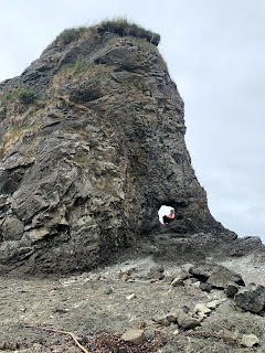
This large sea stack as a hole in it that can be accessed at low tide
The hole in the sea stack is large enough to sit in

view from the hole in the sea stack
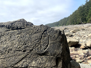
 At the Wedding Rocks, we saw petroglyphs I had seen before, and we found some I had not seen on previous hikes here.
Pano from Cape Alava: Ozette Island in the distance
Ocean view as we hike out of Cape Alava back towards Lake Ozette
 The hike back up to Lake Ozette from Cape Alava seemed to have more ups and downs than the one from Lake Ozette to Sand Point. Either way, they are both lovely forest trails.
large beetle
some wildflowers we saw along the trail today:


No comments:
Post a Comment