

We drove out east of Ellensburg to the Whiskey Dick area to see the wildflowers. There are a couple of different trailheads and roads here. We choose a different trailhead from when we hiked here a few years ago. We started along the Pumphouse Road. Once we left the parking area, we did not see another hikers out here.

As we hiked, we decided to keep going and ended up doing a large loop, about 15 miles with 1,770 ft of overall gain. Our track from today's hike.
 Along the Pumphouse road heading east. Lots of balsamroot in bloom.
 Along portions of the trail we could see the Columbia River to the east.
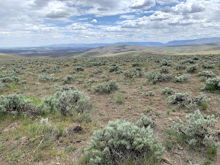
 The trail drops down between the hills for awhile.
 As we hiked up to the ridge, we saw areas affected by a wildfire.
 Looking back at the closed road we hiked up, Columbia River in the distance.
 lots of lupine in bloom
 We then followed the Whiskey Dick Ridge Road
 Lots of wildflowers on the ridge and

in the middle of the road.


We found some petrified wood and left it along the trail.
Pano from Whiskey Dick Ridge: east to south to west:


a harmless snake on the road
 so many wildflowers in bloom


We then took the Whiskey Dick Creek Road down off the ridge. This road connects to the trailhead that is further to the west from where we started.

We then followed a less used connecting road back to near our starting point
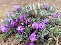
Some of the many types of wildflowers we saw in bloom along the trail today:


 Along portions of the trail we could see the Columbia River to the east.


 lots of lupine in bloom


in the middle of the road.


We found some petrified wood and left it along the trail.
Pano from Whiskey Dick Ridge: east to south to west:


a harmless snake on the road


We then took the Whiskey Dick Creek Road down off the ridge. This road connects to the trailhead that is further to the west from where we started.

We then followed a less used connecting road back to near our starting point
Some of the many types of wildflowers we saw in bloom along the trail today:


