Saturday, August 23, 2014

Rampart Lakes via Rachel Lakes Summer Hike

 We hiked up to Rampart Lakes via the Rachel Lake Trail near Kachess Lake on the east side of Snoqualmie Pass. This is an 11 mile round trip hike with 2,300 ft of elevation gain (most of it in the last mile going up to Rachel Lake). With all the wandering we did around Rampart Lakes, we probably hiked 12-13 miles today.
The trail is mostly in the woods, and soon enters the Alpine Lakes Wilderness. The trail initially climbs up and crosses a creek, then the trail follows Box Canyon Creek for several miles. This portion is a rolling trail going up and down. You will go over many small creeks. There are usually logs or rocks in the water that you can step on to get across.


There are many small cascades in  Box Canyon Creek:


Some are great places to take a break or refill your water bottle.
 There are many creeks coming down the hillside. You can see some waterfalls through the trees.


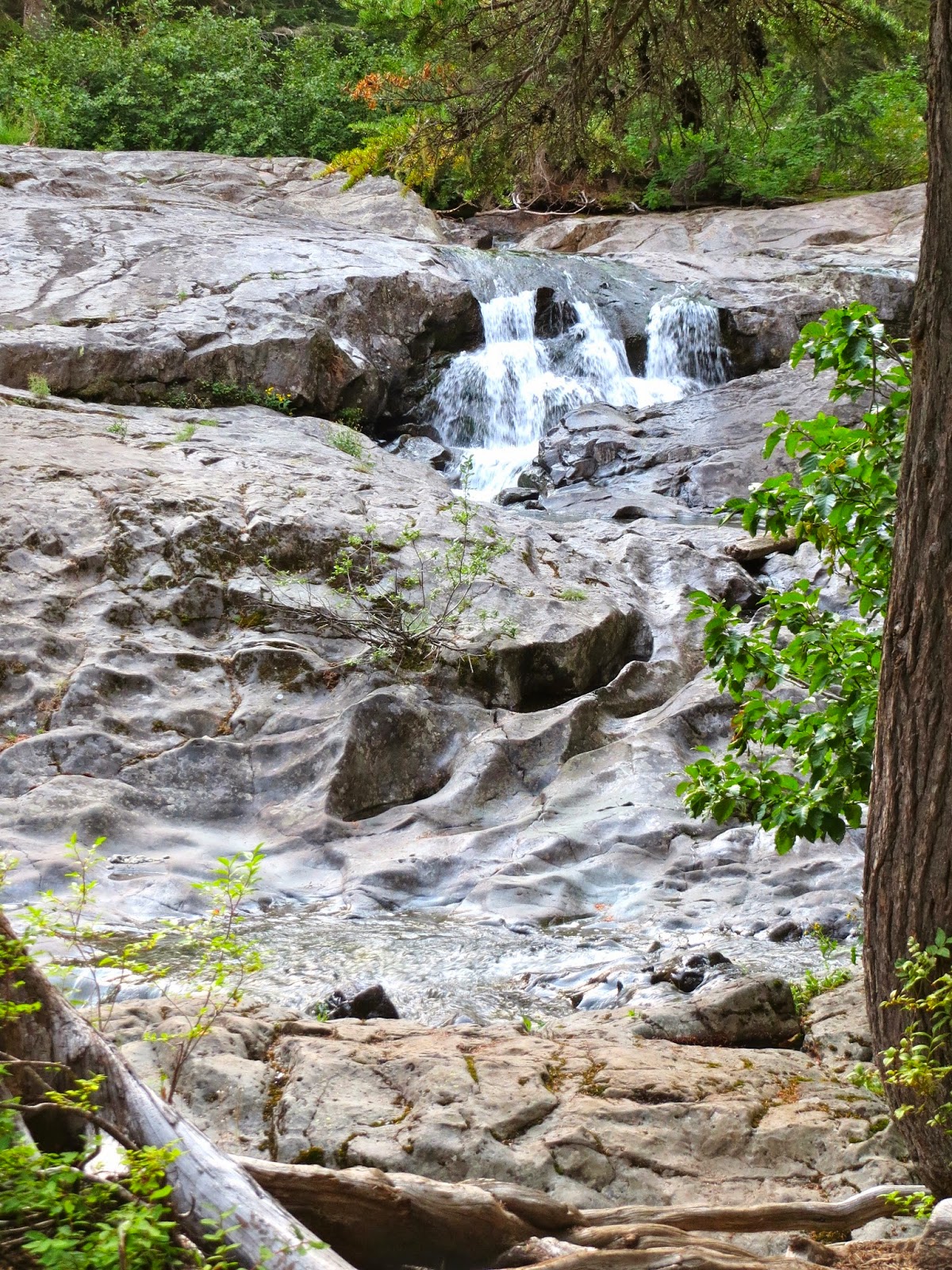
About 2.3 miles from the trail head, you've climbed 400 ft. Now the trail begins to climb steeply. These falls are near the beginning of this steep section, slightly off the trail, they are easily accessible.

Over the next 1.5 miles, the trail will gain almost 1500 ft in elevation gain over a rough trail filled with large rocks and many tree roots on the way to Rachel Lake. Be careful at the switchbacks, as there are old offshoots that have some branches and/or rocks over them to keep you on trail. 


  Along the way (maybe 1/3 up the steep section), you'll cross a creek coming down over this large rock wall. Early in the summer, the water flows over the entire rock, creating a bridal veil falls. This late in August, there is less water, but still a great place to stop and get wet.
After another climb (maybe another 1/3 of the steep section) the trail opens into a clearing. Here you can look back into the valley along Box Canyon where you have been hiking.
There will be one more brief flat section before reaching Rachel Lake.
 We didn't take the time to stop at Rachel Lake today (about 3.8 miles from the trail head with a 1900 ft elevation gain).
Before reaching Rachel Lake, take the trail to the right, that goes around the east end of Rachel Lake. The trail at the end of the lake climbs the ridge behind the lake for 1/2 mile and about 400 ft. There are some great views looking down on Rachel Lake.


At the ridge crest, take the trail to the left to Rampart Lakes (to the right is the trail to Lila Lake and Alta Mountain).
A few feet from this junction on the left, high in the tree, is the sign showing the way).


Here the ridge is narrow. Peeking between the trees to the north, we could see the peaks in the distance.


 The trail goes up and down along the ridge, passing several ponds, for about a mile, before coming across creek that empties from Rampart Lakes. The wildflowers here were beautiful.

 There are several lakes nestled in Rampart Ridge.
 We wandered around the many boot trails going around the lakes.

 The hills between the lakes alternated between tree filled and meadows of wildflowers.
 We climbed up a hill to get a panoramic view of the lakes and surrounding area, while eating our lunch. One of the lakes and part of the west end of Rampart Ridge:
To the east: Alat Mountain and Hi Box Mountain:


 After lunch, we continued on the boot trails, circling the lakes.

 There were also boot trails leading away from lakes
 Behind this lake, you can see the small hill we climbed to eat our lunch.
 More of the lakes

 There was even a small falls, where the creek went from one of the lakes to another.
 Rampart Lakes is a wonderful place to spend an August afternoon.


Here are some of the many wildflowers and berries we saw today:


Wednesday, August 20, 2014

Myrtle Falls, Narada Falls & Christine Falls at Mt Rainier

 Drove up to Paradise on Mount Rainier to see the wildflowers and do a very short hike to Myrtle Falls with my 86 year old mother. From the parking lot near the Paradise Inn, the trail is 0.3 miles to Myrtle Falls. We parked in the lower parking lot, making it about 1+ mile round trip. By parking in the lower lot, we wandered through more trails in the Paradise area where we would see 6 deer and lots of wild flowers.
 The colors were beautiful.
 Mount Rainier stayed hidden in the clouds, but that didn't detract from the beauty of the fields.
There were flowers blooming along Edith Creek
Love the colors.


 View of Edith Creek from the bridge above Myrtle Falls
 Myrtle Falls as seen from the short spur trail.
 After lunch at Paradise Inn, we walked along another trail back to the parking lot, enjoying more flowers.
 On the drive out, we stopped and took the short 0.2 mile trail down to see Narada Falls. Love the rainbow in the falls.


A little further down the road we stopped at Christine Falls. Upper Christine Falls as see from the roadside.

Lower Christine Falls as seen from the very short trail down from the parking area.

Saturday, August 16, 2014

Upper DungenessTrail to Marmot Pass and out via Upper Big Quilcene Trail

 Today, we were dropped off at the Upper Dungeness Trail in the Olympic National Forest (near Sequim); hiked up to Marmot Pass and then hiked down the other side along the Upper Big Quilcene Trail (near Quilcene) for a 13.5 - 14 mile hike with 3,500 ft elevation gain.
We didn't have great views because of the clouds, but there were lots of wildflowers and berries and we enjoyed the hike.


 The first part of the Upper Dungeness Trail is fairly flat and follows the Dungeness River. After one mile and 400 ft of elevation gain, we crossed the log bridge over Royal Creek to continue on the Upper Dungeness Trail and enter the Buckhorn Wilderness.
 Lots of water in Royal Creek.

 The trail continues with a fairly even grade along the Dungeness River.


 After another 1.6 miles, our trail crosses the Dungeness River on a log bridge to continue up river on the west side of this river.
 The trail divides at an unmarked junction shortly before Camp Handy, we hiked the upper trail to the left. This is about 3.4 miles from the trailhead and a total elevation gain of 600 ft from the trailhead.


 Here the trail climbs away from the Dungeness River in a long 3 mile transverse to Boulder Shelter with an additional 1,800 ft of elevation gain. There were several easy water crossings with wildflowers along the way.

 We stopped near Boulder Shelter for a lunch break, we had come 6.4 miles from the trail head and climbed about 2,500 ft from the start.


 From Boulder Shelter area, we headed up to Marmot Pass. This section begins with a series of switchbacks going through fields and forest. This section of the hike is 1.7 miles with about another 1,000 ft of elevation gain.


 Lots of wildflowers along this section.

 The last part of this trail is a gentle traverse as it goes over avalanche fields towards Marmot Pass, seen in the background.


 Lots of wildflowers to enjoy along the trail.

 We sat a little ways above Marmot Pass, enjoying a snack and hoping the clouds would lift. We could only see part of Buckhorn Mountain on the north side of the pass.
 From Marmot Pass the Upper Big Quilcene Trail is 5.3 miles with a descent of 3,500 ft. Just below the pass are beautiful fields of wildflowers.
 There is also a large boulder field where we saw the marmots last summer. None were to be seen on our trip today.


 As we continued down the trail we passed old avalanche chutes filled with wildflowers.


Crossed lots of streams. A couple had waterfalls coming down.


 The last 2.5 miles, the trail traveled alongside the Big Quilcene River.


We were happy to see Matt waiting to pick us up in the parking lot! This butterfly was resting on the ground near the car:


Some of the many flowers, berries, plants and fungi we saw today: