Saturday, December 28, 2013

Snow Lake Winter Hike Washington

Low avalanche risk at the lower elevations and very little snow on the windward slopes today.
So we headed up to Snoqualmie Pass and headed out to Snow Lake.
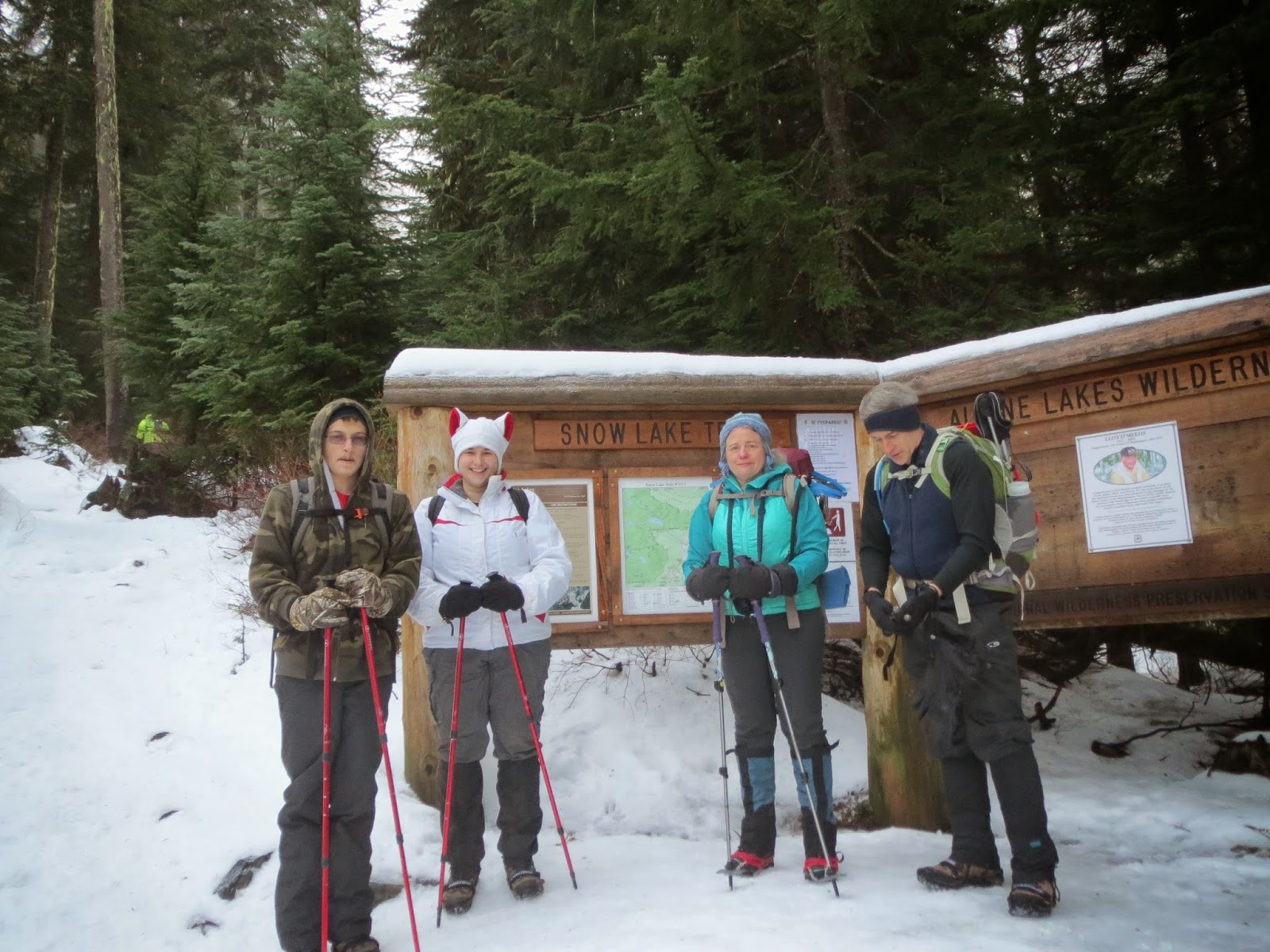
The trailhead is located by the parking lot at Alpental. 
Our hike was about 8 miles round trip and 1400 ft total elevation gain. It's difficult to determine milage on a snow trip, because we're not always following the "official" trail that is under snow.
The first 0.5 miles are steps made to protect the trail. They were very icy. 
Glad we had YakTrax and micro cleats, which made walking easy.
 The trail then gradually ascends for the next 2.5 miles.
 We saw several small waterfalls along the way, most were partially frozen.


After 3 miles from the beginning of the trail, you reach a steep slope with switchbacks heading up to a ridge line. By this time the sun was shinning and we were getting great views of the surrounding peaks.
 Along this slope we saw a completely frozen waterfall.
 The saddle of the ridge is reached at about 3.5 miles and 1000 ft elevation gain from the trailhead. 
Here you enter the Alpine Lakes Wilderness.
As we descended the 400 ft down to the lake, we saw Snow Lake covered in pristine snow.
 We hiked until we came to a sunny spot by the lake on the opposite shore to eat lunch,
and admire the fabulous views.
 By noon, the sun was sinking behind the ridge, and we headed out the way we came in, first up 400 ft.
 On the way back, we turned up the other trail at the base of the ridge climb to Source Lake Overlook.
 

 As we hiked through the lower portion, I noticed the many waterfalls coming down the rocky cliffs.

We had a fabulous day in the sun, enjoying the beauty of the Cascade Mountains.

Saturday, December 21, 2013

Dungeness Spit Hike Washington

On the first day of winter, with rain forecast for most of the Puget Sound area, a hike in the rain shadow near Sequim sounded perfected. We headed out to the Dungeness National Wildlife Refuge for a walk on the beach.  The first 1/2 mile is an easy stroll through the forest.
 Extending over 5 miles into the Strait of Juan de Fuca, 
the Dungeness Spit is the longest coastal spit in the continental US
The south side of the spit is protected bird habitat, so the hike is on the Strait side of the spit.
Low tide was at noon today, perfect for hiking all the way out to the Light station

 There are plenty of birds on both sides
 At the light station
The light station was open and we climbed the stairs to the top
View from light station to the west, looking back over the spit


We saw lots of shore birds.

Saturday, November 23, 2013

Palisades Trail to Little Ranger Peak Fall Hike Washington


 We picked a low elevation hike along Hwy 410 today.  Hike up Palisades Trail toward Little Ranger Peak. Hike 14.5 miles with 2600 ft elevation gain. We saw some ice on the ground in the parking lot, but the first part of the trail was dry.
The trail begins climbing through the forest. With a break in the trees, we could see the first section of the Palisades.
 280 ft Lower Dalles Falls had lots of water.
A nice set of wooden stairs takes you up a steep section of the trail.
 Crossed upper Dalles Creek
From the first open ridge line along the Palisades, we saw a great view of Sun Top Mountain across the White River.
 The trail turns back into the woods to cross Snoquera creek. We began to walk in snow where we saw deer, elk and bear tracks.
At the second open ridge line along the Palisades, we saw Mt Rainier to the southeast. There was a nice long section of open trail here.
 We continued along the trail until we came to Little Ranger Peak, we did the scramble up to the top. Great place for views and a lunch break. Here we could see more of Mt Rainier in the distance. We signed the summit register.
 The descent from Little Ranger Peak was steep, I decided to sit and slide down to the trail.
We returned the way we came. Back at the first ridge line on the Palisades, we stopped to look across the White River to find Skookum Falls in the far distance.

Monday, September 23, 2013

Monitor's Ridge Mt St Helens

We were hoping to climb Mt St Helens today, the day we were able to obtain climbing permits. 
We spent the night in Cougar, and began at Climber's Bivouac in the Rain.
 The first part of the hike is 2 miles through forests with a 1000 ft elevation.
 Then the trail is through and over boulder fields ascending steeply.
 We reached about 5700 ft elevation (2000 ft climb) after hiking 2.75 miles ,
we found the wind to be too strong for us, we were almost knocked off our feet. 
Decided we would turn back and try to get climbing permits for earlier in the summer next year.

Saturday, September 14, 2013

Mildred Point via Comet Falls Hike at Mt Rainier

Another beautiful September day, we headed up to Mt Rainier National Park, and headed up to Mildred Point on the far end of Rampart Ridge, via the Comet Falls trail, since the washed out portion of the trail has been restored. Our hike was 8 miles with 2500 ft elevation gain.
 The trail climbs steeply the first 0.3 miles and crosses Van Trump Creek above Christine Falls.
The next 1.7 miles continues to climb, but not as steeply through the forest. 
There are several smaller falls along Van Tump Creek.
 

 The trail also crosses a couple of open avalanche chute areas,
 we were fortunate to spot a pica among the rocks.
About 2 miles from the start of the trail, a bridge crosses Falls creek. 
There is a short spur trail that stays on the right side of the creek, getting close to the base of this waterfall. Some people stopped here thinking they were at Comet Falls, 
but this pretty waterfall is unnamed and just 0.25 miles short of reaching Comet Falls.
 After crossing the bridge, the trail takes a turn around a small bend, and soon 320 ft Comet Falls comes into view. The falls are reached within 0.2 mile, and a short spur trail takes you to a plunge pool at the base of the falls. This is about 2.5 miles from the start of the trail and a 1200 ft elevation gain.
As we climbed the switchbacks on the trail beyond the falls, we looked down and spotted a rainbow.

After climbing 500 ft in about 0.5 miles, the trail splits, to the right is Van Trump, to the left, the trail we took, to Mildred Point. This trail descends 100 ft and crosses Van Trump Creek above Comet Falls. After crossing the creek the next 0.5 miles is a nice flat hike along the opposite shore, before the trail splits. Staying on the main trail, takes you down Rampart Ridge to Longmire, the split to the right, up to Mildred Point, our destination.
 
The last section of the trail is 0.5 miles and climbs over 500 ft. There are three sections of this trail, a steep climb through a meadow. We frequently stopped to look at the gorgeous views behind us. We could see the southern Cascade mountains, including Mt St Helens and Mt Adams (obscured by the haze in the photo).

Then a less steep section, where we began to see Mt Rainier in front of us. We stopped and ate lunch here.


then another steep climb through a meadow.  There were still some wildflowers at this high elevation so late in the summer. And the views were even better.

At Mildred Point, we stayed for a while to enjoy the view of Success Point (300 ft below the true summit), and Kautz and VanTrump Glaciers. Mildred Point is at 5935 ft elevation.  Off to the left is Wilson Glacier.


 We returned back the same way we hiked up. Saw some interesting fungi in the woods.