Friday, January 31, 2020

Teanaway Community Forest Snowshoe

We drove out to the Teanaway Community Forest to go snowshoeing, we did 7.25 miles with about 1,025 ft of overall elevation gain.
We began by hiking across the West Fork of the Teanaway River on a bridge.


It was foggy and lightly raining when we began.
a large sandstone boulder
a nice mixture of fir and pine trees
lichen on some of the trees, brightened up this gray day
We took a short break up at Bible Rock
the views today were of foggy valleys
On our return, we snowshoed up to Cheese Rock


there are some tall pine trees here
view by Cheese Rock was mostly foggy, with some views of the ridge across the valley
looking out across the other way


the sun began to come out as we were returning back to the trailhead

small frozen pond back near the bridge

on the drive out, we saw some turkeys cross the road, I was able to get a photo of one of them.

Tuesday, January 28, 2020

Crystal Mountain Snowshoe Trails

We drove up to Crystal Mountain Ski Resort to try our the newly marked snowshoe trails. To access the trails we parked in the upper C lot. There was a mixture of clouds and blue sky when we arrived.


We started up the lower Blue Bell Loop, then went up the Mary Lee Trail and turned up the Bullion Loop, going up the right side of the loop and came down Ted's Trail back to Mary Lee and then down the upper Blue Bell Loop. We missed the turn down towards the trailhead and continued down a closed forest road for quite a ways. Eventually we returned up the road and found a ski path that took us down through some housing area and ended up in the F lot. We rode the shuttle back up to the C Lot. Overall we snowshoed about 4-5 miles and gained about 800 ft. Fun day!

At the start of the trail we went up some ski tracks, then broke trail as we choose different routes to take.
Peek of a distant peak
We had the sun trying to break through the clouds while it was snowing for awhile. We took turns breaking trail.
I love being out in the fresh snow.

Occasionally there would be a break between the trees and we could see the ski area across the way.


small stream near the trail
heading down what ended up being a closed forest road
another view across to the ski area


Was very happy to find a bridge over Silver Creek on our cross country trek back to the parking areas.

Sunday, January 26, 2020

Ranger Falls and Green Lake

Drove up to the Carbon River Entrance at Mt Rainier National Park to hike up to Ranger Falls and Green Lake (9.6 miles round trip with 1,500 ft of gain), on the hike back we went up a side trail to an old mine (0.6 miles round trip with 170 ft of gain).
The first 3 miles of the trail is along the permanently closed Carbon River Road (very little incline).
Early on, we watched 3 deer, one at a time, cross the road in front of us.
This is a beautiful forest to walk through.
The woodpeckers really like this old stump
We encountered a few downed trees along the trail, that were fairly easy to go over or around.
About 3 miles from the trailhead, there is a nice view of Tirzah Peak across the Carbon River.
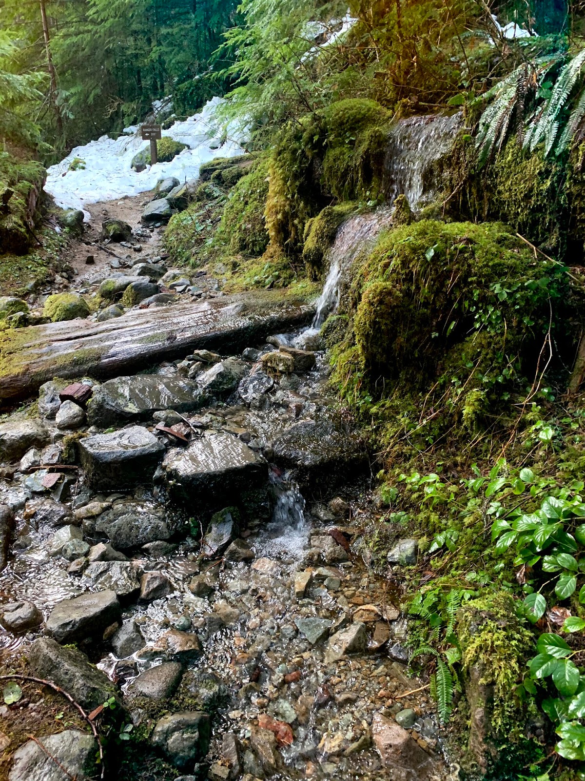
There was some intermittent snow going up the trail to Ranger Falls, we did not need snowshoes or microspikes.
From here it is 1 mile to Ranger Falls and an additional 0.8 miles to Green Lake,
We were happy to see some sunlight through the trees on what was forecast to be a very rainy day.
There were more downed trees on the way up to the falls and the lake.
Water running down the trail shortly before the short spur trail to Ranger Falls.

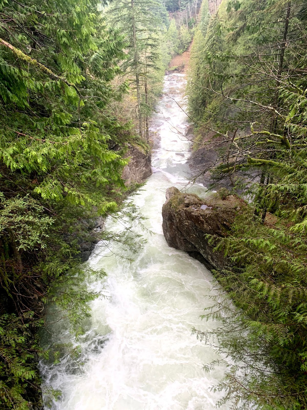
There was lots of water flowing in Ranger Falls today.


small orange fungi


After Ranger Falls, the snow was more consistent on the way up to Green Lake, but we did not need to use snowshoes or microspikes
Shelf fungus growing up the side of the trees.
We were pleased to see the log bridge crossing Ranger Creek was not icy or snow covered today.
Green Lake was mostly covered in ice.
Nice spot for a lunch break.
lovely lichen on dead logs
The trail to the old mine is about 1 mile from the parking area at the  Carbon River Entrance, we hiked up here on our way back.
a short steep trail up in the forest
mine entrance
view of the mine through the slats covering the entrance to the mine
lovely forest, full of trees, ferns, moss, lichen, and fungi

Friday, January 24, 2020

Twin Falls Trail

We drove up to Olallie State Park to hike the Twin Falls Trail from the lower trailhead to where the trail joins the Iron Horse Trail and back again. This was 4 miles round trip with an overall elevation gain of about 1,000 ft. This trail runs parallel to I-90 and the freeway traffic can be heard for the majority of the hke.
Trail is in a beautiful forest.

The lower section of the trail is along the South Fork of the Snoqualmie River.
View of the lower Twin Falls from the bench overlook.
About 1 mile up the trail, there is a short spur trail to an overlook close to the lower falls
Twin Falls from the overlook


0.1 mile further up the trail a bridge crosses over the South Fork of the Snoqualmie River above the lower falls. View downstream from the bridge.
View up stream from the bridge
A little ways further up the trail is this overlook of the upper falls.
The trail then veers away from the river and goes uphill through the forest until it joins the Iron Horse Trail.
We saw fungus
and beautiful moss covered trees
This stump was covered in lichen and tiny pink fungi
more views of the forest along the hike


 lots of ferns growing up this tree


blue sky as we returned to the beginning of the trail.