Saturday, March 22, 2014

Snowshoe to Eagle Peak Mount Rainier

We went up to Longmire at Mt Rainier National Park today. Drove across the Nisqually River to the Community Center where we had a gorgeous view of Mt Rainier. We hiked up the road about 200 yds to the Eagle Peak trailhead. The hike is to the saddle between Eagle and Chutla Peaks a distance of 7.2 miles round trip with 2900 ft elevation gain. We did not make it all the way up the trail. We did about a 5 mile round trip with about 1800 ft elevation gain.
 This trail is mostly in the forest and starts climbing right away. We were glad to see their were footprints in the snow, showing someone was ahead of us, blazing the trail. There were a couple of large trees on the trail to be climbed over.
 At about 4000 ft, we put on our snowshoes as we were post holing. The group ahead of us did not use snowshoes and were post holing ahead of us. There was over 12" of deep powdery snow, making for slow hiking with only two us with snowshoes.
 I found the bridge crossing a bit daunting, as the snow and ice on top was uneven and there was no handrail. We took off our snowshoes to cross and I used micro cleats for added traction.
We continued snowshoeing until it was time to stop and eat lunch. We found a small clearing in a sunny spot to stop and eat. We had passed the group that was hiking ahead of us. They also turned back before reaching the saddle.
We enjoyed our hike, it was much easier going down, and there were a couple of places where we could see between the branches to Rampart Ridge across the Nisqually River.
I want to go back and do this hike when the trail is snow free.

Sunday, March 16, 2014

Reflection Lakes & Louise Lake snowshoe on Mt Rainier

We drove up to Mt Rainier National Park today for an easy snowshoe hike to Reflection Lakes and Lake Louise, sticking to the no avalanche field trail (because of the increased avalanche risk today). Our hike was about 7 miles round trip with an overall elevation gain of about 900 ft.
We hiked in a light rain for most of the day, it was still beautiful, even with the limited views. We choose the trailhead at Narada Falls. The hike through the forest followed Paradise River for awhile. It was fun watching the river appear and disappear in the snow.
To avoid the avalanche fields along the Stevens Canyon Road as it passes Inspiration Point, the winter trail goes up and over Inspiration Saddle and then drops down to Reflection Lakes.

Because of the rain and limited views, I forgot to take a picture of one of the Reflection Lakes. If you want to see a photo and a description of a longer loop hike, see this post from last Wednesday.
After reaching Reflection Lakes, we continued on the snow covered Stevens Canyon Road for about 0.75 miles with a gentle descent for this overlook of Louise Lake.
The Stevens Canyon Road was an easy trail.  We returned the same way we traveled out, going over Inspiration Saddle back to Narada Falls.
We had the lakes to ourselves today. We didn't see other snowshoers until we were going back up to Inspiration Saddle.

Saturday, March 15, 2014

Lena Lake & Valley of Silent Men Winter Hike Washington

 We were looking for a hike in the eastern Olympic Mountains today, we chose the Lena Lake Trail (a 6 mile round trip) and then to continue along the Valley of the Silent Men (the Brothers Trail) toward the Brothers Base Camp (for a 13.4 mile round trip). We didn't make it all the way to the Brothers Base Camp, as we had a late start and didn't reach it by our turn around time. We hiked about 9 -10 miles with about 2500 ft elevation gain. The trailhead is 8 miles up the Hamma Hamma road off of Hwy 101. The trail begins at 650 ft, and quickly starts climbing up a series of switch backs.
The trail climbs about 1000 ft in 1.9 miles to reach the 1st bridge which crosses over an old dry creek bed, Lena Creek travels underground here.
 The second bridge is 0.7 miles further up the trail with only 200 ft of elevation gain. Here you can watch a creek tumble down the hillside.
Another 100 ft of elevation gain over 0.4 miles (3 miles from the trailhead), you reach a large rocky ledge overlooking the southern end of Lena Lake 100 ft below.
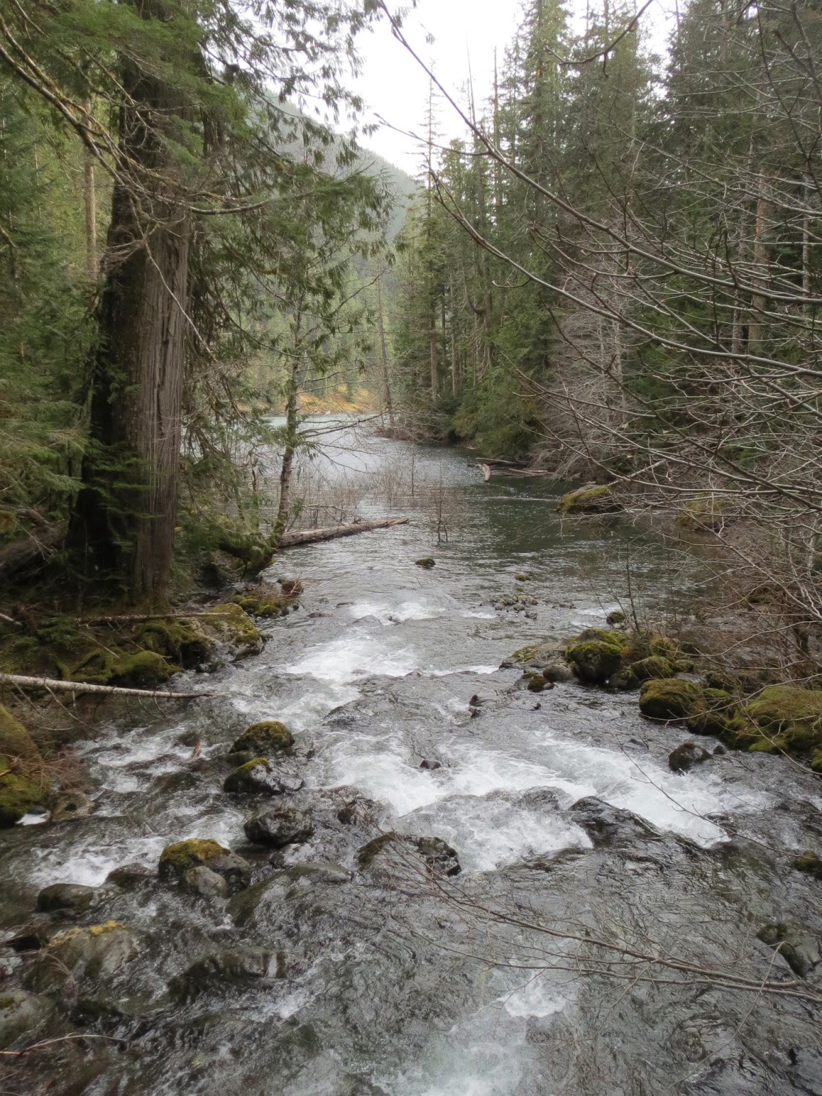
 After enjoying the view, we continued on to the north end of Lena Lake and crossed Lena Creek. It's worth stopping half way across the log bridge to enjoy the views:
To the north, Lena Creek comes tumbling down over the rocks, and to the south, watch Lena Creek as it enters Lena Lake.

The trail to the Brothers begins 3.6 miles from the Lena Lake trailhead, at the northeast end of Lena Lake. This trail travels through the forest, crossing the East Fork of Lena Creek 5 times as it travels 3 miles and climbs 1400 ft to the Brothers Base Camp. At one of the crossings, we could just make out a small waterfall behind some boulders.

 There were many downed trees along the trail this winter, one fallen tree had taken off the hand rail at this log crossing. At a couple of places, the trail had been washed out and new routes had been made off trail. We did hike over snow in some places, but didn't need to use our snowshoes.
We would have to look through the woods and around some fallen trees to see some of the beautiful cascades.
We were going to stop for lunch at one spot along the trail with beautiful mossy covered boulders, but the smell of fresh skunk discharge encouraged us to hike further up the trail away from the smell and a chance encounter with that skunk.
We needed to turn around before reaching the Brothers Base Camp, due to time restraints. I want to return one day, to finish this hike.
 On the way back down, the sun momentarily broke through the clouds to give us a clear look at Lena Lake from the north end of the Lake.


Wednesday, March 12, 2014

Narada Falls to Reflection Lakes to Mazama Ridge to Paradise Loop Snowshoe trip

 Beautiful clear sunny day in Western Washington, we headed up  to Narada Falls on Mt Rainier to begin our snowshoe trip. We decided on a loop hike of about 6 miles and 1200 ft elevation gain. The trail head was in the shade, windy and very cold. We quickly warmed up as the hike starts on a steep up hill for 0.5 mile.
 We choose to snowshoe to Reflection Lakes via inspiration point. The avalanche chutes were still in the shade and the cool of the morning was keeping them stable. This was a nice flat section of the trail for about one mile. Beautiful of Mt Rainier behind us.
We did a short stop at Reflection Lakes to enjoy the view and take photos.
 Then the ascent of Mazama Ridge, part way up, as Mt Rainier came back in view, we stopped to enjoy lunch.
We also had gorgeous views of the Tatoosh Range to the south. The winter route up Mazama Ridge is about 2 miles, much shorter than the summer route. We had tracks to follow the whole way.
 Ready to begin our descent of Mazama Ridge.
Steep 0.5 mile descent to the roadway via 4th crossing.
 Slow ascent up the road to Paradise.
Then another steep descent from Paradise down to Narada Falls. Today's hike was a walk in a winter wonderland!

Sunday, March 9, 2014

Upper Dungeness River Winter Hike Washington

 With rain forecast for most of Western Washington today, up to 7000 ft, we decided to head out to Washington's rain shadow: Sequim. It was raining until we pulled off onto Louella Road, we were rewarded with clouds parting and a glimpse of the Olympic Mountains.
 As we continued up on Forest Road 2880 we saw lots of blue sky and more views of the mountains. We also saw a fisher run across the dirt road, this is the first time I've seen one in the wild.
 I was surprised to see snow at 2500 ft, there was quite a bit in the parking lot. We had left our snowshoes at home, so we only made a 5.2 mile round trip with 500 ft elevation gain. We didn't see any people prints on the trail, so it looks like no one has been one the trail since the last snow storm. We saw lots of animal prints: deer, wild cat and a smaller print I hadn't seen before, maybe the fisher?
There were lots of streams crossing the trail, as the snow is melting.
 At one mile we crossed Royal Creek on this log bridge as we continued up the Dungeness River.
 As the trail continued in the forest, the snow got a bit deeper, and we ran into several places where the trail was a creek. We went off trail onto the snow when the water was deep.
 We were rewarded with our efforts, when the sun came over the ridge and brightened our path.
 At 2.6 miles another log bridge crosses the Dungeness River and continues on to Camp Handy (another 0.8 miles) and after that you can choose to hike out to Heather Creek (another 3+ miles) or up to Boulder Camp (another 3 miles and 1800 ft elevation gain) and even further to Marmot Pass and beyond.
We found a place in the sun to eat our lunch and decided to head back. The log looked slippery, the river deep and flowing fast. I didn't want to risk falling in.
 Heading back to the trailhead, clear view across the river and a view of one of the Olympic peaks.
We saw some type of a monotrope, pine drops maybe? Maybe spring will be here soon.

Saturday, March 1, 2014

Kendall Peak Lakes Snowshoe Washington

 Today we headed up to Snoqualmie Pass for a great snowshoe hike. The trailhead to Kendall Peak Lakes is across I-90 from Hyak. The trail mainly follows a logging road. We went around this downed tree early on. This is a popular hike, so the snow was nicely packed down for us. It is a 9 mile roundtrip hike with 1900 ft of elevation gain.

As we followed the logging road up on top of the ridge, the wind was very cold, we were glad when the trail left the road and went into the woods towards the lakes.


 The lake is in a nice sheltered area, very little wind here. We sat by the frozen lake enjoying our lunch.


On the way down, we took the spur trail to the overlook, not much of a view with all the clouds today. But we spent a little more time in the beautiful outdoors!