Monday, September 23, 2013

Monitor's Ridge Mt St Helens

We were hoping to climb Mt St Helens today, the day we were able to obtain climbing permits. 
We spent the night in Cougar, and began at Climber's Bivouac in the Rain.
 The first part of the hike is 2 miles through forests with a 1000 ft elevation.
 Then the trail is through and over boulder fields ascending steeply.
 We reached about 5700 ft elevation (2000 ft climb) after hiking 2.75 miles ,
we found the wind to be too strong for us, we were almost knocked off our feet. 
Decided we would turn back and try to get climbing permits for earlier in the summer next year.

Saturday, September 14, 2013

Mildred Point via Comet Falls Hike at Mt Rainier

Another beautiful September day, we headed up to Mt Rainier National Park, and headed up to Mildred Point on the far end of Rampart Ridge, via the Comet Falls trail, since the washed out portion of the trail has been restored. Our hike was 8 miles with 2500 ft elevation gain.
 The trail climbs steeply the first 0.3 miles and crosses Van Trump Creek above Christine Falls.
The next 1.7 miles continues to climb, but not as steeply through the forest. 
There are several smaller falls along Van Tump Creek.
 

 The trail also crosses a couple of open avalanche chute areas,
 we were fortunate to spot a pica among the rocks.
About 2 miles from the start of the trail, a bridge crosses Falls creek. 
There is a short spur trail that stays on the right side of the creek, getting close to the base of this waterfall. Some people stopped here thinking they were at Comet Falls, 
but this pretty waterfall is unnamed and just 0.25 miles short of reaching Comet Falls.
 After crossing the bridge, the trail takes a turn around a small bend, and soon 320 ft Comet Falls comes into view. The falls are reached within 0.2 mile, and a short spur trail takes you to a plunge pool at the base of the falls. This is about 2.5 miles from the start of the trail and a 1200 ft elevation gain.
As we climbed the switchbacks on the trail beyond the falls, we looked down and spotted a rainbow.

After climbing 500 ft in about 0.5 miles, the trail splits, to the right is Van Trump, to the left, the trail we took, to Mildred Point. This trail descends 100 ft and crosses Van Trump Creek above Comet Falls. After crossing the creek the next 0.5 miles is a nice flat hike along the opposite shore, before the trail splits. Staying on the main trail, takes you down Rampart Ridge to Longmire, the split to the right, up to Mildred Point, our destination.
 
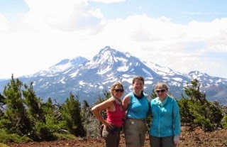
The last section of the trail is 0.5 miles and climbs over 500 ft. There are three sections of this trail, a steep climb through a meadow. We frequently stopped to look at the gorgeous views behind us. We could see the southern Cascade mountains, including Mt St Helens and Mt Adams (obscured by the haze in the photo).

Then a less steep section, where we began to see Mt Rainier in front of us. We stopped and ate lunch here.


then another steep climb through a meadow.  There were still some wildflowers at this high elevation so late in the summer. And the views were even better.

At Mildred Point, we stayed for a while to enjoy the view of Success Point (300 ft below the true summit), and Kautz and VanTrump Glaciers. Mildred Point is at 5935 ft elevation.  Off to the left is Wilson Glacier.


 We returned back the same way we hiked up. Saw some interesting fungi in the woods.
 

Wednesday, September 11, 2013

Glacier Basin Hike on Mt Rainier

Last night we camped at the White River Campground at Mt Rainier National Park, 
so we could have another day of hiking on the mountain. 
The trailhead is on the far side of the campground, so no need to drive.
We continued hiking awhile beyond Glacier Basin Camp,
so our hike today was 9 miles with 2200 ft elevation gain.
After a nice 1 mile hike through the forest, there is a side trail (Emmons Morraine Trail) to overlook the Emmons Glacier (the largest glacier in the lower 48 states).
We thought this 1 mile round trip spur trail was worth the extra time.
The lower portion of the Emmons glacier is covered in rocky debris (moraine),
 note the White River coming out of the ice cave in the lower left corner of the photo.

We continued on the main trail, which follows the Inter Fork section of the White River.
Most of this hike was in the forest (wonderful on this very hot day) 
but we did get some fabulous views of the Mountain
We decided to continue hiking beyond the end of the "maintained" trail after Glacier Basin Camp,
up towards St Elmo Pass seen in the background 

We climbed to the top of this ridgeling which climbs about 400 ft above Glacier Basin Camp

This was a great spot to see Inter Glacier and the source of the White River.
We thought this ridge was very steep climbing up and descending.
Another marvelous day on Mt Rainier!


Tuesday, September 10, 2013

Panhandle Gap Hike Mt Rainier

My sister Laraine and my daughter have been wanting to hike up to Panhandle Gap on Mt Rainier and I was happy to go along. 12 mile round trip and 3000 ft elevation gain on a beautiful sunny day.We started at the trailhead at Frying Pan Creek.
 About 3 miles up the trail we enter the meadows, no wildflowers here, but plenty of colorful berries.
Mt Tahoma seen in the background.
 the gentian was just opening at Summerland (4.2 miles & 2000 ft up the trail)
 Mt Rainier and Mt. Tahoma in the background
There was a lot less snow here today, than when I was here 9 days ago, 
we could see a lot of snow melt, water pouring off the glaciers.

at Panhandle Gap (6 miles and 3000 ft up the trail)
 looking Northwest from where we hiked up
 at Panhandle Gap, the view to the Southeast, including Mt Adams and Mt Hood 
 Mountain Goats seen high up the Cowlitz Ridge 
 On the way down, we looked back and saw the moon rising over Panhandle Gap


Sunday, September 8, 2013

Alpine Lookout Hike Washington

We got early and drove up to Stevens Pass for this hike in the Wenatchee National Forest.
We started at the Round Mountain Trailhead for a 10 mile round trip with 3100 total elevation gain.
In the first 0.5 mile you climb almost 1000 ft in elevation. Here you hike through an old burned area, the view to the southeast sbles the Blue Mountains.
 The next half mile of trail is an easier grade.
 About 1.5 miles along the trail, you reach the Nason Ridge Trail up towards Round Mountain.
There a couple of viewpoints, to the northeast, Glacier Peak (zoom lens)
 to the southeast, Lake Wenatchee
 The trail skirts around Round Mountain and to the west, we can see the small green peak where the Alpine Lookout is located (near the center of the photo behind the trees)
The trail descends from the ridge line before climbing up to the lookout.
At the summit by Alpine Lookout.
 to the north, Glacier Peak
 to the north east, a look back to Lake Wenatchee
 to the southeast, Stevens Pass and more Cascade Mountains
 to the east, the eastern Cascade Mountains
 We saw lots of interesting fungi