 Drove up to Paradise at Mt Rainier National Park today to snowshoe on this beautiful sunny day. I decided to snowshoe up to Glacier Vista and over to Myrtle Falls. Total 3.25 miles with 1,000 ft of gain. There was a decent track heading up towards Panorama Point since the last snowfall.
 Looking back towards the Tatoosh Range.
 Beautiful snow covered trees
 Everyone ahead of me was heading up to Panorama Point, there was no track heading towards Glacier Vista so I starting breaking trail, with Mt Rainier in front of me the entire way. Feels so good to be out on the snow in the sun.
 As I continued up to Glacier Vista, I stopped to look back towards the Tatoosh Range with Mt Adams, Mt Hood and Mt St Helens appearing behind the Tatoosh. I had this piece of Paradise to myself!
 View of Mt Rainier with the Nisqually Glacier below.
 As I continued upwards, I looked back to see if anyone was coming up behind me and could help break trail, but it was just me.
 A frosty tree and exposed boulders that have not yet been buried in snow above 6,000'.
Panorama of the view to the south: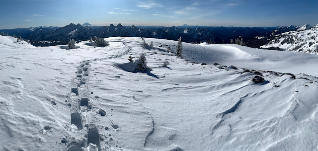

I continued up to 6,400' but did not take more photos, was enjoying the views and the solitude on a busy, sunny Saturday at Paradise.

Frosty tree, and in the background, skiers and snowshoers heading up to Panorama Point.

As I snowshoed back down, I could see a couple of groups who had come up behind me, but stopped further down and were now enyoying a break. I love this view on the way down from Glacier Vista!

Taking a look back at Mt Rainier and my solo tracks up to Glacier Vista.

I met many others heading up as I snowshoed down and over to Myrtle Falls. For awhile, I had this view to myself as well.

Today was beautiful with a gorgeous blue sky!

I saw some animal tracks in the snow near Myrtle Falls.

View of the Tatoosh Range as I head back to the parking area from Myrtle Falls.


 Everyone ahead of me was heading up to Panorama Point, there was no track heading towards Glacier Vista so I starting breaking trail, with Mt Rainier in front of me the entire way. Feels so good to be out on the snow in the sun.
 View of Mt Rainier with the Nisqually Glacier below.
 As I continued upwards, I looked back to see if anyone was coming up behind me and could help break trail, but it was just me.
 I continued up to 6,400' but did not take more photos, was enjoying the views and the solitude on a busy, sunny Saturday at Paradise.
 As I snowshoed back down, I could see a couple of groups who had come up behind me, but stopped further down and were now enyoying a break. I love this view on the way down from Glacier Vista!
 I met many others heading up as I snowshoed down and over to Myrtle Falls. For awhile, I had this view to myself as well.