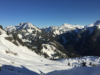
Today we drove up to the Mount Baker Highway to hike up to Yellow Aster Butte. This is a 7.5 mile round trip hike with 2,550 ft of gain. We felt today's conditions were safe to hike in this normally avalanche prone area.
The first 3/4 mile of the trail had little snow. On the first switchbacks on the open slope, we had a gorgeous view of Mt Baker.
After that first 3/4 mile, the trail was consistently covered in snow, we wore our microspikes as several sections were very icy.
Our first view of Yellow Aster Butte

Most of the trail was well packed down, but there were a couple of areas where the wind had covered the trail with fresh snow and we did some post holing.
Standing below Yellow Aster Butte

View of Mt Shuksan at the creek crossing

Continuing up the trail
Mt Baker and a local peak
The winter "trail" takes a short cut going straight up to a ridge below Yellow Aster Butte.
I didn't feel comfortable going up the last 200 ft to the end of the trail on Yellow Aster Butte with the steepness of the trail and the exposure. There was not enough snow to get good kick steps. I opted to stay on this ridge, enjoying the views and my lunch while my friends continued on to the top.
Wide angle view from the ridge looking north to Tomyhoi Peak, Yellow Aster Butte on the right.

view of Mt Baker from the ridge
Pano from the ridge south to west: Mt Shuksan and Mt Baker
Pano from the ridge west to north: Mt Baker to Tomyhoi Peak

Enjoying this beautiful day in the North Cascades

My shadow below Yellow Aster Butte
Heading back down the trail, looking towards the peaks to the east
Some interesting icicles on a boulder.
Watching the sun go down near Mt Baker as we finish our hike
 We drove 4.5 miles up the Twin Lakes road off of Mt Baker Highway to the Yellow Aster Butte Trailhead. This trail is 7.2 miles round trip with 2,550 ft of gain. This trail has fabulous views and lots of wildflowers in the late summer. The trail starts of steep, gaining 1,500 ft in less than 1.5 miles. There is a short section where the trail traverses an open meadow before entering the forest. Here we saw fireweed, yarrow, coastal hedgenettle along with other wildflowers in bloom.
 The trail does a wide arc around the basin through fields of wildflowers, gaining elevation at an easier pace.


