Wednesday, January 31, 2018

Snow Bowl Hut Overnight Snowshoe

We had reservations to spend the night at Bruni's Snowbowl Hut, one of MTTA's huts near Ashford. Although the upper Sno-Park lot was open, the weather forecast was for 4 - 8" of new snow, so I felt safer parking at the lower Sno-Park. This made our trip 8 miles round trip with 2,200 ft of elevation gain. There was only a little snow along the side of the road by the parking area, enough to pull my sled.
By the time we reached the Upper Sno-Park, there was close to 8" of snow and it began snowing heavily.
The entire route is up closed forest roads. This is a great place to snowshoe in poor avalanche conditions as there are no avalanche risks along the main routes.


There are several streams along the way.

We took turns pulling the sled.
We had some breaks from the snowfall.
It was a winter wonderland with all the fresh snow.
The turn off to Snow Bowl Hut is about 2.5 miles from the lower parking area. As we crossed the saddle towards the Snow Bowl Hut, we had some blue sky.
After enjoying a nice flat area along the saddle, the road again climbs uphill. I was happy to see the roof of the hut peeking above the trees.
Snow Bowl Hut!
On a clear day, there are great views of Mt Rainier, Mt Adams and Mt St Helens. Today we only had views of local hills, but they were beautiful with all the new snow.

In the evening, the full moon broke through the clouds for a while. (very fuzzy photo taken with my phone).
Snow Bowl hut at night.

In the morning, there were too many clouds to see the lunar eclipse. I walked to the gazebo a short ways down the ridge.
As we snowshoed back down the trail, I enjoyed all the snow covered trees and landscapes.


Friday, January 26, 2018

Westside Road in Mt Rainier National Park Snowshoe

 We were fortunate that the snow level has come down to 2,000 ft, so we were able to do a winter hike/snowshoe up the closed Westside Road in Mt Rainier National Park. I think this gravel road goes 12 miles up the westside of Mt Rainier. Some years ago the road was closed 3 miles up due to Tahoma Creek washing out a portion of the road. In the winter this road is closed shortly after turning off the main road into the park.
There is no risk of avalanches along the first 3 miles of the road (the portion which is open in the summer). As the avy condition was considerable today, this was a nice safe option. 6 miles round trip with 750 ft of elevation gain.
There was only an inch of snow at the beginning of the road. We did not put our snowshoes on for the first two miles.
 This is mainly a walk through the forest. There were a couple of small streams along the side of the road.
 In the summer, I have driven up this section of the road not paying much attention. It was nice to have the time to enjoy the forest here today.

 There were several places where Tahoma Creek comes close to the road

 The only other tracks we saw were some animal tracks. We did not see any other people here today.
 Snow covered trees are so beautiful


 another view of Tahoma Creek

 Occasionally, the clouds would move and we could see nearby ridges.

 some lovely moss
another ridge
 Mt Wow as seen from 3 miles up the road. We decided to take a lunch break and turn around here as we had no need to walk past the large boulder field and avalanche chute.
 Some more views of Tahoma Creek as we walked back down the road


Wednesday, January 24, 2018

Little Mashel Falls

Hiked up to Little Mashel Falls this morning to see how they looked with all the recent rain we've been having. About 5 miles round trip with 500 ft of elevation gain.

Decided to hike up via the Bud Blancher Trail in Eatonville. The first 1.4 miles are along a gravel travel that goes by some homes and a road.
 Shortly after crossing the second bridge, there is a sign marking the turn off to the Little Mashel Falls Trail.

Nice forest walk on the way to the falls


 View of Lower Little Mashel Falls from the
side trail heading down to the falls.
Wide angle shot of Lower Little Mashel Falls. The spray in the upper portion of the photo is from Middle Little Mashel Falls

 View of Middle Little Mashel Falls from the side trail leading down to the falls
There was so much water and spray from the middle falls, I had a difficult time getting a photo. We were soaked from the spray here.

 There is another side trail leading to where Little Mashel River drops down into Middle Little Mashel Falls.

We were short on time today, so we decided to skip the trail leading to the upper falls.

Friday, January 19, 2018

Green Lake

 Hiked up to Ranger Falls and Green Lake from the Carbon River Entrance of Mt Rainier National Park, a 9.6 mile rt hike with 1,150 ft of elevation gain. We also hiked further up the Carbon River hoping to cross the river and go to Chenuis Falls, but the bridge was out and we did not see any safe crossing, so we hiked about 11.5 miles overall today.
This was the first time I've down this hike with no measurable snow!

 The first 3 miles of the hike is fairly flat and goes along the closed Carbon River Road. It is a beautiful forest.

There are many shades of green.


 Tirzah Peak along the Carbon River
 At 3 miles, we reached Ranger Creek, here is the trailhead to Ranger Falls and Green Lake. From here, it is 1 mile and 600 ft of elevation gain to Ranger Falls and an additional 0.8 miles and 500 ft of elevation gain to Green Lake.


There were several small streams along the way,

 and lots of interesting trees, ferns, moss, etc.
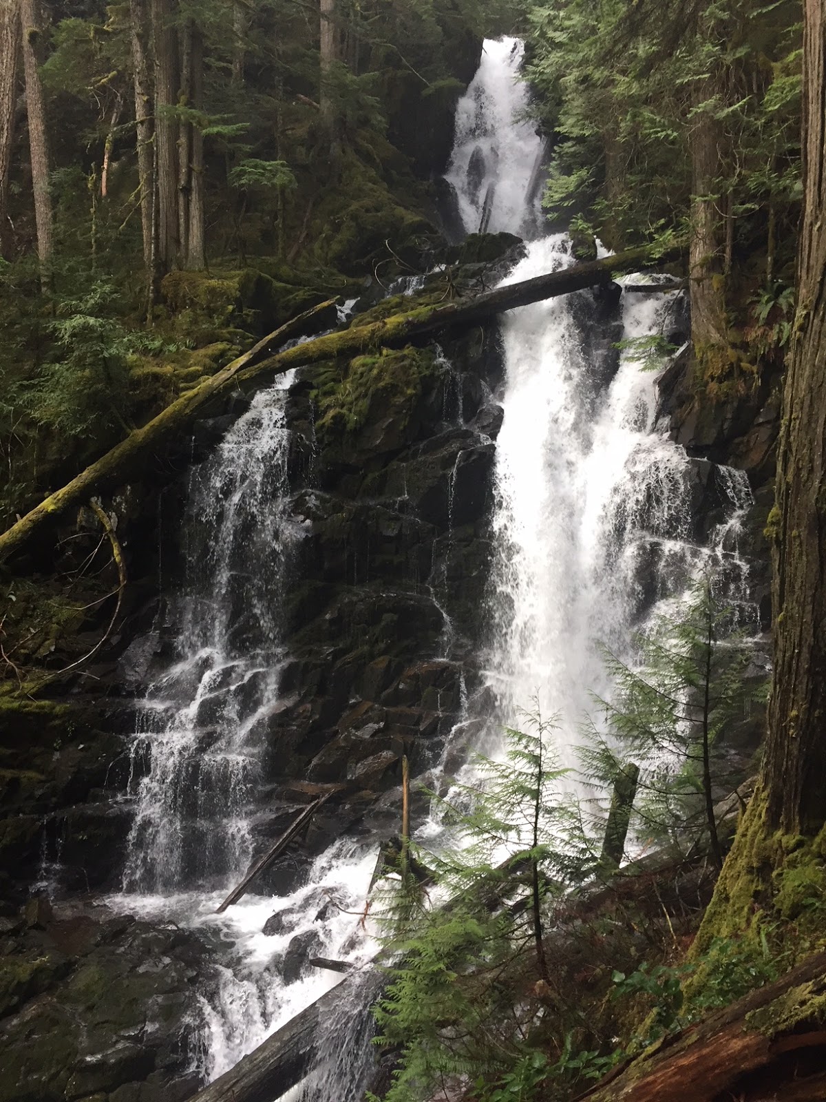
 a short 200 ft spur trail leads to an overlook of Ranger Falls
 Lots of water in the falls today.
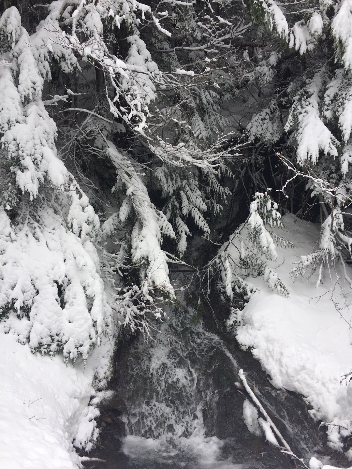
As we neared the bridge crossing Ranger Creek on our way to Green Lake we saw a light dusting of snow.
 This light dusting did make the log bridge slippery.


 First glimpse of Green Lake, I loved the light dusting of snow on the logs at the lake edge.
Wide angle shot of Green Lake. The ice did not completely cover the lake. Tolmie Peak is in the far distance.

 After enjoying a lunch break at the lake, we returned to the closed road and hiked about another mile + up the Carbon River,
 enjoyed the views along the river.


At 0.7 miles from the trailhead to Ranger Falls and Green Lake, we reached where the bridge to Chenuis Falls had once been. We could sort of see the falls behind the trees. 
There were a couple of large trees that had fallen across the Carbon River, but they did not appear to be a safe way across.

 Beautiful color on a Pacific Yew.
there was some budding on the moss/lichen