Wednesday, May 29, 2013

Multnomah Falls to Wahkeena Falls Hike Loop Hike

Another beautiful hike along the Columbia River Gorge on the Oregon Side.
 620 ft Multnomah Falls can be seen from I-84, better to exit and walk up to the base of the falls. 
We decided to do the loop trail from Multnomah Falls to Wahkeena Falls with several smaller waterfalls in-between. Our hike was 5+ miles with 1550 ft elevation gain.
 From the base of Multnomah Falls is a 1.1 mile trail of 9 switchbacks and 740 ft elevation gain
 to a short 0.1 mile spur to look out over the top of Multnomah Falls.
 After the spur, continue to climb up through the forest and you'll pass several waterfalls.
First small Dutchman Falls,
 50 ft Wiesendanger Falls,

55 ft Ecola or Hidden Falls,
shortly after these falls, we took the trail that traverses across the slopes toward Wahkeena Spring.
 Then we followed the trail down along Wahkeena Creek to 20 ft Fairy Falls
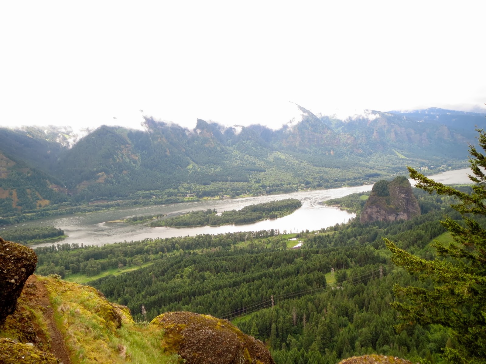
 As the trail descends, we found a nice look out over the Columbia River.
 At 4.5 miles, you've returned down to the base of the cliffs 
and have a wonderful view of 242 ft Wahkeena Falls.
 Looking back at Wahkeena Falls through the forest.
A 0.5 mile connector trail takes you back to Multnomah Falls, 
we found this "weeping" rock along the way.

Tuesday, May 28, 2013

Hamilton Mountain Washington

The hike to Hamilton Mountain, along the Columbia River Gorge on the Washington State side, can be done as an in-and-out hike or as a loop. We choose the loop option. 
It was 8 miles and about 2100 ft elevation gain.
 Amble parking near the trail head 0.3 miles off of State Route 14
 
 The hike begins in the forest, but soon we were walking through a large field with wildflowers.
 Looking ahead, we saw our destination Hamilton Mountain, 
and just below is a rocky ridge with wonderful views.
 About 1.1 miles, Hardy Falls
 Nearby is the side trail up to the Pool of Winds, definitely worth the short climb up hill. 
 As you climb, you see the top of Rodney Falls behind the rock. 
 At the end of the viewing area, you see where Rodney Falls burst through a tight chasm into a small punchbowl, the wind bursts through here, fabulous experience.
 Continue back to the trail, cross a bridge, to see more of Rodney Falls. A short distance further on is a junction, take the trail to the right for the best views on the way up to Hamilton Mountain.
 the trail climbs upward, with many opportunities to view the Columbia River to the South and the Oregon Cascade Mountains beyond. Beacon Rock is to the right on the Washington side of the river.
 More views as we continue to climb.
 
 More wildflowers as we cross higher meadows
 From the top of Hamilton Mountain the only views are to the East and the North.
 Follow the north ridge down from Hamilton Mountain to the saddle, where there are great views. 
We choose to take the Dons Cutoff Trail for our loop trail. 
where we found wild ginger

Monday, May 27, 2013

Eagle Creek Oregon

Beautiful hike found along the Columbia River gorge in Oregon. We hiked 12.5 miles round trip (with the extra 0.5 miles to add Twister Falls to the day) with 1100 ft elevation gain (more if you do some of the side trips down to the falls and back to the trail).
 The trail head is about 0.5 miles off on I-84, easy to find. We hiked on a wet Memorial Day. We didn't mind the rain, it kept the crowd down on this very popular hike.
 Lush green valley, several areas had these "weeping" rocks

Metlaka Falls 100 ft  about 1.5 miles up the trail

At 1.7 miles up the trail, take the 100ft spur trail down to the creek. Walk to the center of the creek for a great photo op of….

Punch Bowl Falls 35 ft (lower view)
At 1.9 miles up trail, over look of Punch Bowl Falls

 The trail climbs up, eventually to 1000 ft above the creek. There are cables along the cliff to hold on to when the trail is slippery.

 Crossing High Bridge

 Lowitt Falls 90ft, about 3 miles up the trail
 6 miles up the trail is 1200 ft Tunnel Falls, difficult to see through the trees.
Continue up the trail.
 A tunnel behind the falls leads you to the opposite of the falls and the creek.
 Emerging out of the tunnel
 View of Tunnel Falls from the trail before it goes around the bend.
 A short 0.25 miles after Tunnel Falls, lies 200 ft Twister Falls. 

Some of the wildflowers among the rocks.


Sunday, May 26, 2013

Angel's Rest & Bridal Veil Falls Oregon

These hikes are along the Columbia River Gorge National Scenic Area in Oregon. We choose a short hike today, as it was almost afternoon when we started. Angel's Rest is less than 5 miles round trip with about 1500 ft elevation gain. 
 Trail head is easily marked.
 150 ft Coopey Falls


Lots of wildflowers in May
Along the trail, Angel's Rest is in the background, just above the trees.
Almost to Angel's Rest, 1600 ft above the Columbia River, Washington State across the river.

 Downstream to the West
 Upstream to the East 
At the same exit off I-84 is the short 0.6 mile trail to Bridal Veil Falls
120 ft Bridal Veil Falls