The first 3 miles of the trail is along the permanently closed Carbon River Road (very little incline).
Early on, we watched 3 deer, one at a time, cross the road in front of us.
This is a beautiful forest to walk through.
The woodpeckers really like this old stump
We encountered a few downed trees along the trail, that were fairly easy to go over or around.
About 3 miles from the trailhead, there is a nice view of Tirzah Peak across the Carbon River.
There was some intermittent snow going up the trail to Ranger Falls, we did not need snowshoes or microspikes.
From here it is 1 mile to Ranger Falls and an additional 0.8 miles to Green Lake,
We were happy to see some sunlight through the trees on what was forecast to be a very rainy day.
There were more downed trees on the way up to the falls and the lake.
Water running down the trail shortly before the short spur trail to Ranger Falls.
There was lots of water flowing in Ranger Falls today.
small orange fungi
After Ranger Falls, the snow was more consistent on the way up to Green Lake, but we did not need to use snowshoes or microspikes
Shelf fungus growing up the side of the trees.
We were pleased to see the log bridge crossing Ranger Creek was not icy or snow covered today.
Green Lake was mostly covered in ice.
Nice spot for a lunch break.
lovely lichen on dead logs
The trail to the old mine is about 1 mile from the parking area at the Carbon River Entrance, we hiked up here on our way back.
a short steep trail up in the forest
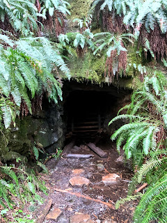
mine entrance
view of the mine through the slats covering the entrance to the mine
lovely forest, full of trees, ferns, moss, lichen, and fungi


No comments:
Post a Comment