In the afternoon, we continued a few miles east on Hwy 12 to the trailhead of Upper Calf Creek Falls. This is a 2+ mile round trip hike with 600 ft elevation loss/gain. The trail immediately descends down slick rock.

We made sure to make note of the cairns and how we would return on the way back
 As we neared the falls, the trail splits in to: to the left, the trail descends down to the bottom of the falls; to the right, the trail heads to where Calf Creek drops down to the falls. We choose to first hike down to the left.
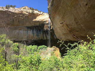
View of Upper Calf Creek Falls, as we dropped down the trail. We had to watch our step as there was lots of poison ivy here.
Wide angle view of 88 ft Upper Calf Creek Falls:
 We then returned to the trail split and continued to where Calf Creek drops into the falls:
 There creek forms some shallow pools on its way to the falls


No comments:
Post a Comment