The trail starts by going across a large wooden bridge over Lostine River.
Looking upstream of the Lostine River
This is a wooded trail that crosses several open slopes. In the lower section we saw numerous woodland flowers in bloom. The first 2.5 miles of the trail gently go up long switchbacks, gaining about 1,600 ft.
a short ways up the trail there are logs for crossing over Maxwell Creek
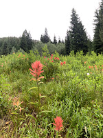
Immediately after crossing Maxwell Creek, the trail goes through this filed which was filled with paint brush, mariposa lillies and so much more.
 A bit higher up, we crossed a field full of hyssop and views of water tumbling down Hurricane Ridge across the valley.
Another field was full of bluebells, paintbrush and asters.
The views improved as the trail gained in elevation, In the very far distance, we saw part of a snowy peak and wondered if it could be Eagle Cap Peak.
The next 0.8 miles of trail goes straight uphill gaining 800 ft.
We passed a bog, lined with Labrador Tea and filled with elephanthead lousewort and bog orchids
We passed a snowy ridge on our way up
Heather was in bloom along the trail
After reaching 7,844 ft in elevation, the trail drops down for 0.2 mile to Maxwell Lake.
Maxwell Lake is a gorgeous alpine lake
another view of Maxwell Lake
We found a large rocky mound to take a break and enjoy the view.
As the clouds moved around, we saw the lake turn from blue-green to blue-gray
Heading back down from Maxwell Lake, we enjoyed the views of Hurricane Ridge and going back through the many fields of wildflowers
some of the many wildflowers we saw in bloom along the trail today:


No comments:
Post a Comment