Drove up to the Tubal Cain Parking area in the Northeast Olympics to hike up to Tubal Cain and Buckhorn Lake. Overall 13 miles and 3,100+ ft of elevation gain.
The trail crosses Silver Creek almost immediately.
The first mile or so of trail is lined with rhododendrons. The trail follows above Copper Creek for several miles.
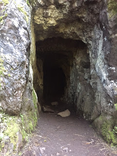
 After 3 miles, there is a spur trail up Tull Canyon. This mine entrance can be seen from both trails. Not too far into the mine entrance, the way is blocked off.
This spur trail gains 1,100 ft in 0.7 miles.
There are several streams crossing over the trail, most were easy to cross.
Logs over the creek near the upper meadow in Tull Canyon. We saw several campsites up here.
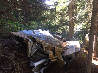
Pond and meadow where remnants from a B 17 that crashed in 1952 are strewn.
Photos from some of the wreckage, very sad that people have left graffiti where some men lost their lives.
We returned back to the main trail. About 3.6 miles from the trailhead is the site of the Tubal Cain mine to the left. This is still private land. We decided not to explore this area, but crossed Copper Creek (where there is no bridge) and continued towards Buckhorn Lake.
The trail soon starts climbing up to open meadows on a ridge to the west of Copper Creek. There were lots of wildflowers in bloom.
There were several large patches of melting snow above the trail, causing water to run over the trail and cause some trail erosion.
Soon we were able to see Iron and Buckhorn Mountains,
Pano of the ridge line to the east:
 At 5 miles from the trailhead, the trail splits. To the left: 0.5 miles to Buckhorn Lake. To the right: the trail continues for another 3.2 miles to Marmot pass.
 We took the trail that goes down and up and down several times to Buckhorn Lake. We had one wide shallow stream crossing along the way.
Beautiful view from our lunch spot watching the trout swim in this icy cold lake.
Some of the many flowers we saw in bloom along the trail today:


No comments:
Post a Comment