Large streams have torn up the road here making it very difficult for cars to pass. We had no difficulty crossing on foot.
With all the rain softening up the road over the years it feels more like a trail than a road.
We did have some nice views of the Dosewallips River and the Mt Jupiter Hills as we hiked.
After 1.2 miles, we reached the road washout and took the switchbacks on the left up an over a plateau before returning down to the old road.
As the road meanders, we would get peek a boo views of the Dosewallips River.
There were many small streams flowing from the other side of the road/trail.
After 5.5 miles, we reached the Olympic National Park Boundary.
There were a few downed trees along the way, all easy to maneuver around.
Another stream, this one covered in downed trees.
An old rock slide before the road goes around a large rock cliff. A short ways after this, the road was covered in patchy snow.
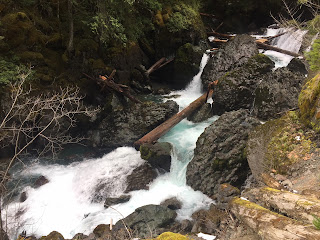
Here is the "waterfall" section of the Dosewallips River.
So amazing to watch the river cascade down between boulders.
 Once we walked passed the "waterfall" section, the road was consistently covered in snow. We did not need to use snowshoes nor traction.
 View of the Dosewallips River as it comes our from the campground.
Lots of beautiful trees surrounding a meadow at the campground.
 There was about 6" of snow here. We saw some deer in the campground and only a couple of other people.
We found a lovely spot along the Dosewallips River to take a lunch break.
 On our hike back, we stopped to look at the alternate river route where the large washout occurred. As we couldn't see where the trail was after the fallen log, we decided to play it safe and hiked back over the switchbacks on the detour route.


No comments:
Post a Comment