 We drove to the Westside Road at Mt Rainier National Park to do the loop hike up Tahoma Creek to the Suspension Bridge, then up to Emerald Ridge and around the other side and back down the Westside Road a 13 mile hike with 3,100 ft of elevation gain.
We parked where the Westside Road is currently closed, so needed to hike 1 mile up the road to the Tahoma Creek Trail. We had a nice view of Mt Wow along the road.
 For a while the road follows Tahoma Creek with a brief view of Mt Rainier in the distance.
 Because of trail washouts, there is no trail sign by the road, but a worn trail can be seen, and a brief way up the trail is a "Trail is not maintained" sign.
Part of the trail follows along the river bed along the Tahoma Creek, cairns can be found marking the way to the trail in the forest. The trail drops down to the creek again, it's important to look out for the cairns to find the way back to the trail.
 There are some nice streams along the way.
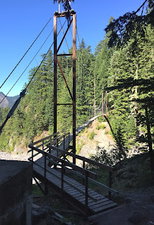
After 2.2 miles along the Tahoma Creek Trail joins the Wonderland Trail. To the north is Emerald Ridge, but first we went about 1/8 mile to the south to the Tahoma Creek Suspension Bridge.

The Tahoma Suspension Bridge is 200 ft long and is 165 ft above Tahoma Creek.
Two spots had missing slats on the bridge.
Looking back down on the Tahoma Creek Suspension Bridge from the Emerald Ridge Trail.
There were a few wildflowers in bloom along the trail.
Panoramic view from Emerald Ridge and the Tahoma Glacier
We decided to hike along the boot track to the base of Glacier Island,
for a closer look of Tahoma Glacier.
Panoramic view from atop Emerald Ridge.
Some views of wildflowers and Mt Rainier from the north side of the Emerald Ridge trail as we hiked down.

There were some interesting rock formations along the trail.
There was also some trail erosion.
We came out at Round Pass, where there is a memorial to the marines who were in an airplane that crashed onto the Tahoma Glacier in 1948.


No comments:
Post a Comment