We found a nice day to do this 19+ mile hike with between 3,500- 4,000 ft of elevation gain (depending on which hiking guide you look at. We started early so we could take our time, and complete the hike in daylight. The Sol Duc trailhead is found a the south end of the Sol Duc Road.
At 0.9 miles along the Sol Duc Trail, is found the High Divide Loop Trail. We opted to hike the loop counterclockwise.
The trail immediately crossed a bridge over the Sol Duc River, where the 48 ft Sol Duc Falls can be seen. From here the Deer Lake Trail is straight across the bridge.
The Deer Lake Trail climbs up in a beautiful forest. We found ripe berries.
There are several small stream crossings
A doe and fawn met us on the trail.
Beautiful weeping rock
There is lots of moss and ferns and wildflowers here.
View of Deer Lake from the north end, the trail continues around the east side of the lake.

We took a short break along the east side, and could see a doe with two fawns walking along the far shore (zoom).
At the south end (head) of the lake, the trail continues straight ahead. (To the right, the Low Divide trail heads west to join the Mink Lake Trail.) Our trail goes through Potholes Meadow, where there are several ponds.
After the Potholes Meadow, the trail climbs up to a saddle, here a panorama looking east, the meadows below.
Trail along the saddle.
About 6.8 miles from the trailhead, the view opens up in an alpine basin, where the trail travels for about a mile, with many wildflowers in bloom.
We also passed some areas of recent snow melt, where there were many avalanche lilies in bloom.
We only found one snow field to cross and it was not in a dangerous area.
Continuing along side of the alpine basin.
At 7.3 miles, we reached the Seven Lakes Basin trail, we hiked a couple hundred feet along this trail, until we reached a rock cropping where we could look down upon Lunch and Round Lakes
We then returned to the main trail, enjoying the views and the many wildflowers.
Panorama looking westward, along this section of the trail:

About 7.5 miles from the trailhead, the trail goes up a steep slope in a series of steep switchbacks:
Looking down at the trail and switchbacks.
After the switchbacks, the trail crossed over the ridge, where we had a view into the Seven Lakes Basin looking eastward, Bogachiel Peak is to the far right.

The trail then crossed over the ridge back to the west side, we could see the top of Mount Olympus as the trail continued toward the junction with the Hoh Lake Trail at 8.6 miles.
Wide angle view to the west from the junction of the High Divide Trail and the Hoh River Trail.
Wide angle view to the east from the junction of the High Divide Trail and the Hoh Lake Trail. The Hoh River is 4,000 ft below

About 0.2 of a mile further along the trail, we took the short spur trail (with 275 ft of elev gain) up to the top of Bogachiel Peak. Here we could see Mount Olympus to the south and
the Seven Lake Basin to the north. Lots of snow had melted since I was up on Bogachiel Peak 3 weeks ago. I think we are looking at Lunch Lake, Clear Lake, Long Lake and Morganroth Lake
The trail then continues along the High Divide for 2 miles. After Bogachiel Peak, the trail drops to a wide meadow on the ridge crest. Looking back westward, toward Bogachiel Peak and the Seven Lakes Basin.

Lots of wildflowers in bloom along the High Divide
The trail then climbs up again over a rocky, double- summited peak on the High Divide.
View to the north, Lake No 8 and

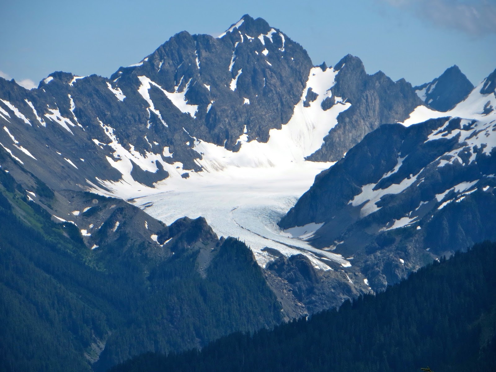
to the south, a great view of Mount Olympus, the Blue Glacier visible on the west side.
Zoom of the Blue Glacier.
At 10.5 miles from the trailhead, the trail begins to drop steeply to the south. Heart Lake is seen to the north, the trail back to Sol Duc goes right past this lake.
Here we found fields of white and pink heather blended together.
From the north end of Heart Lake, looking south to the trail along the ridge line of the High Divide.
From here the trail begins to descend steeply. The head waters of the Sol Duc River and Bridge Creek.
There were lots of wildflowers in bloom at Sol Duc Park.
The trail again entered the forest, and there were many creek crossings, some on rocks or logs and some log bridges
High footlog crossing is at 13.8 miles from the trailhead (5 miles back to the trailhead)
Under the bridge is another waterfall
The trail continues, sometimes through meadows filled with flowers,
mostly in the forest, with many creek crossings
This was a wonderful hike!
Some of the many wildflowers we saw in bloom and other flora along the trail:


 SaveSave


 We took a short break along the east side, and could see a doe with two fawns walking along the far shore (zoom).


 About 7.5 miles from the trailhead, the trail goes up a steep slope in a series of steep switchbacks:


 About 0.2 of a mile further along the trail, we took the short spur trail (with 275 ft of elev gain) up to the top of Bogachiel Peak. Here we could see Mount Olympus to the south and

 Lots of wildflowers in bloom along the High Divide


No comments:
Post a Comment