We drove out beyond Quilcene to hike the Big Quilcene River Trail to Marmot Pass. From Marmot Pass we hiked up to the meadow part way up Boulder Ridge to the south of Marmot Pass. We hiked 11 miles round trip with 3,800 ft of elevation gain.
The first 2.5 miles of this trail goes through beautiful forest following the Big Quilcene River upstream.
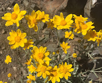
There were lots of woodland wildflowers in bloom along the trail.
The trail goes by a couple of small waterfalls/cascades and crosses multiple streams.

About 2.5 miles from the trailhead, the trail passes Shelter Rock Camp and begins to climb up away from the river.
After another 1 - 1.5 miles the trail opens up as it crosses avalanche chutes with views of the peaks to the south along the Quilcene River drainage.
Many wildflowers lined the trail and we had great views of Bouldler Peak and Boulder Ridge.
As the trail continued through the avalanche chutes, we could see Marmot Pass ahead, before our view would disappear aw we rounded a bend.
We enjoyed the colors going up the avalanche chute towards Iron Mountain to the north.
After crossing the Avalanche chutes, the trail re enters the forest and reaches Camp Mystery at 4.5 miles from the trailhead, the climbs steeply up to Marmot Pass, 5.3 miles from the trailhead.
Panorama to the west from Marmot Pass. Boot tracks to Boulder Ridge on the left and to Buckhorn Peak (and trail to Tubal Cain) to the right.
 To the west, we could see clouds rolling up and covering the trail we had hiked this morning. Glacier Peak was seen in the far distance between the two cloud layers.
We decided to hike up to the meadow on Boulder Ridge a short ways past the snow field.

We saw some mountain goats high up on the ridge.

The snow field was soft and easy to cross. It felt safer than the steep track with loose dirt and rocks going up Boulder Ridge.
Pano part way up Boulder Ridge looking south to west to north. More clouds were coming up from the Tubal Cain trail area.
 The views and wildflower filled meadow made for a gorgeous lunch spot at 6,300 ft of elevation.
The boot track continues on, climbing up Boulder Peak for those who are interested.
It was hard to leave this beautiful place.
Only some of the many wildflowers and other flora we saw:


No comments:
Post a Comment