 Today we drove down to Mt St Helens to hike up to Coldwater Peak from Johnston Ridge. This was a 12.8 mile round trip hike with 2,000 ft of elevation gain (the majority in the last 3 miles). Fabulous views of 4 volcanoes, 2 lakes, wildflowers and fall colors, we also enjoyed ripe huckleberries.
 On the drive up we saw some deer on the side of the road.
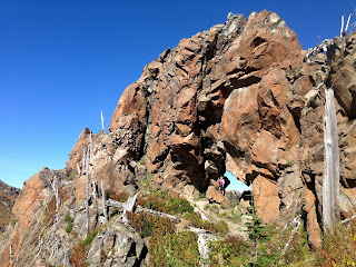
 From the east end of the parking lot, we could look to the northeast to see Coldwater Peak (on the left) and Natural Arch on the ridge line to the right (the trail goes through this arch!)
Zoom shot of the ridge line with Natural Arch, it is a very steep section of the trail.
From the Johnston Ridge parking lot, we followed Boundary Trail 1. The trail heads east/southeast towards Mt St Helens as the trail drops about 200 ft. There are lots of great views of Mt St Helens along this portion of the trail.
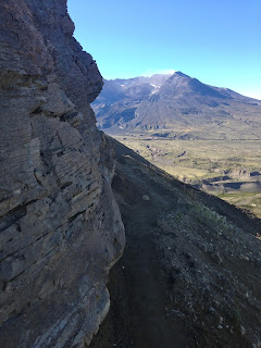
At about 2 miles, you reach an area described as "More Difficult Trail". This section is a narrow trail along a steep, exposed slope as you go around a ridge line. This trail had recently been repaired after a portion had washed out.
Narrow exposed trail heading toward Mt St Helens.
Looking back along this portion of the trail. There is a drop off of over 1000 ft on this part of the trail.
 After getting around the ridge, we found another sign stating the next section was a "Most Difficult Trail". We didn't find the trail difficult for at least another 2 miles.
 At 2.5 miles, stay left where the Truman Trail joins the Boundary Trail. We soon saw the south end of Spirit Lake and Mt Adams in the distance to the east.
Looking north, Coldwater Peak in the Center of the ridge line on the right, Harry's Ridge on the left.
 We crossed a bridge over a dry creek.
At 3.5 miles from the trailhead (4,400 ft of elevation), there is a spur trail (one mile) going up Harry's Ridge. We continued on the Boundary Trail to the north. Here the trail starts to climb up a ridge line to the east of a saddle before Coldwater Peak .
We could see the north end of Spirit Lake with Mt Adams in the distance.
As the trail climbed up, the views got better and better. Looking south at Mt St Helens. We had good views of the glaciers surrounding the dome in the center of the crater.
Panorama: Mt Adams and Mt Hood is the distance behind Spirit Lake and Mt St Helens
 When the trail went around the north side of this ridge crest at 5,200 ft, we had our first view of St Helens Lake, with Mt Rainier just beginning to peak over the ridge line on the other side of the lake.
 As we reached the end of the ridge line, we wondered where our trail was going. It dropped after a steep switchback, down and back toward Natural Arch.
The trail goes through Natural Arch from the west side to the east side.
View of St Helens Lake and Mt Adams from the east side of Natural Arch.
The trail on the east side of Natural Arch was very narrow and exposed, with a long drop off towards St Helens Lake.
 The trail dropped down towards a saddle (5,070 ft), where the boundary trail reaches a junction with the Coldwater Trail 5.2 miles from the trailhead. Coldwater Peak in the distance.
Here looking back towards the saddle and Mt St Helens and Mt Hood in the distance.
 Nearing the summit of Coldwater Peak.
 View to the north, Mt Rainier in the distance.
Our lunch spot on Coldwater Peak, note the steep drop off on the left side. Mt Rainier in the background to the north.
However, there was a higher rocky point on Coldwater Peak, Mt St Helens to the south.
Panorama view to the east, atop Coldwater Peak (from our lunch spot): Mt Rainier, St Helens Lake, Mt Adams, Spirit Lake, Mt Hood, Mt St Helens, rocky point on Coldwater Peak.
The views continued to be fabulous on the hike back down. We stopped to eat ripe huckleberries and enjoyed the fall colors.
The lighting to the east was better in the afternoon. Overlooking Mt Adams, Spirit Lake, Mt Hood and Mt St Helens.
 One of our final views of the crater of Mt St Helens as we neared the end of our hike.
We saw this garter snake on the trail. He stopped to pose.
Some of the many wildflowers and other plants we saw along the trail today:


zooms of Mt. Rainier and Adams are the same mountain? Your photos and description are wonderful! I can't wait to go on this hike.
ReplyDeleteThanks Kathy for pointing that out, they were both Mt Adams. I was up way too late posting photos. I have since fixed that problem and have the correct zoom of Mt Rainier as seen on our hike.
DeleteThis comment has been removed by the author.
ReplyDelete