Saturday, March 5, 2016

Ozette Triangle Winter Hike

Drove to Lake Ozette in Olympic National Park to hike the Ozette Triangle. This is a 9 mile "loop" hike. We ended up hiking a bit further along both ends of the beach trails for a hike of about 11 miles and 350 ft of elevation gain. This is 8 - 10 miles south of Point of Arches, where we hiked to yesterday.

 The weather was better than expected, and we arrived earlier than planned. Some young deer greeted us as we drove into the National Park at Lake Ozette.


 The trail starts near the north end of Lake Ozette and crosses over the outlet of the Ozette River

The trail soon divides. We decided to take the right trail to the north and Cape Alava, hike down the beach to Sand Point and return via the trail on the left.

The 3.2 miles to Cape Alava is mostly in the beautiful costly forest. A lot of the trail is boardwalk, there is one section with new synthetic boards,


 but most is old cedar boardwalks, some of this was very slippery.
 We did hike through a couple of meadows,
 some areas were quite wet.
 The trail's arrival at Cape Alava. Ozette Island in the distance. We arrived at high tide, so decided to explore the camping areas to the north above high tide, then hike along the beach as the tide receded.
 A log bridge crosses a creek on the way to the camping areas.
 Parts of the forest trail were very wet!
Pano along Cape Alava, Ozette Island and Tskawahyah Island


 We passed the old Makah Ranger Station.
and neared Tskawahyah Island, where lots of bald eagles were flying overhead. The tide was too high for us to reach the island by foot.


 Standing at the western end of Cape Alava (not counting Tskawahyah Island) we could look north and see in the distance the Point of Arches, where we hiked to yesterday. We then hiked on the beach back to the north end of the Ozette Triangle trail, sometimes going over driftwood to avoid the higher waves as the tide continued to recede.
 The coast here is a mixture of firm sandy beaches, soft sandy beaches, and rocky beaches.


There were lots of bald eagles flying overhead today. We saw this one resting on a large boulder near the forest edge:


 Nearing Wedding Rocks, at high tide there is a trail over the headland. This is about 1.6 miles down the beach from the trail at Cape Alava.


We did not need to take the trail over the headland, but there was still a bit of water and slippery rocks along the edge, so we climbed over some rocks.
The Wedding Rocks, we were about 1/2 along our route, so took a break to eat lunch and enjoy the sun and views!!!

 We found some of the petroglyphs among the rocks,


 some of these are hundreds of years old.
 We continued along the beach towards the next headland, as the tide continued to recede, we could stay on the beach. Looking back towards Wedding Rocks.
 This section of the beach had lots of large sea rocks


on top of the larger sea stack we saw
another bald eagle


 There were a variety of shore birds out today.

Pano along this section of the beach with the tide going out

 On some sections, there was so much kelp over the rocks that there were super slippery. Here we opted to hike higher up the beach. We didn't need to take the trail over the headwall however.

 Looking back up the beach to the north and my footprints in the sane
 Here, the waves broke far out from the shore. There were some very large breaks
Pano of the last section of the beach, Sand Point to the left.
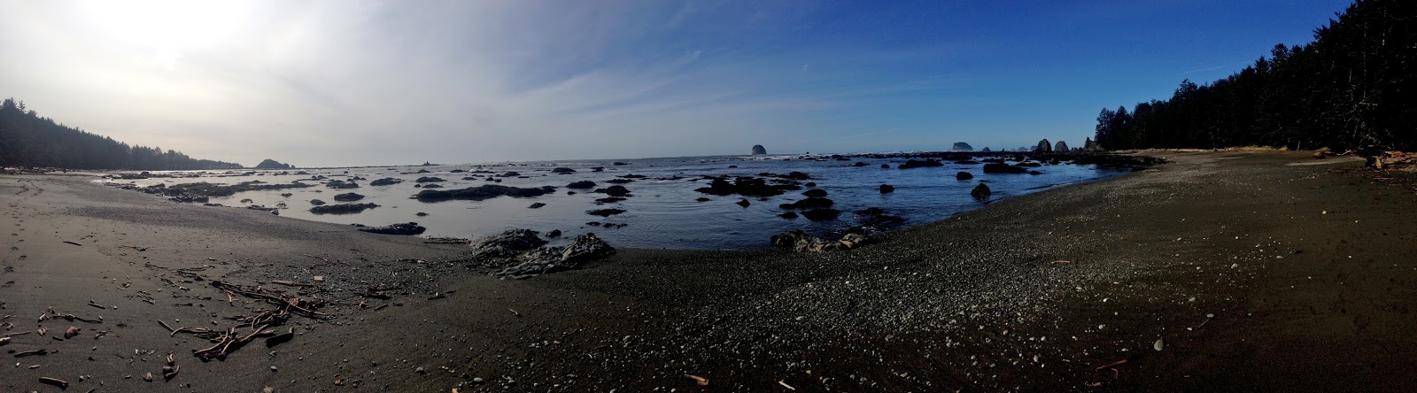
 We saw many shore birds: great blue heron, grebe, cormorants, mergansers, and lots of seagulls.
 Looking north from Sand Point, I love the blue sky, sea and shore!!!!


 There is a large grassy hill at the end of Sand Point with a trail to the top.
Pano from atop the hill, looking from west to north to east (Sand Point)
 Pano from atop the hill, looking east to south to west, lots of beautiful sandy beaches and rocky tide pools.

 We explored the camping areas at Sand Point, some very, very wet trails here.
 Time to return. along the 3 mile trail from Sand Point back to Lake Ozette, mostly cedar boardwalk.

 Lots of skunk cabbage in bloom.


Our trip ends at Lake Ozette.

Friday, March 4, 2016

Cape Flattery Winter Walk

 After our hike to Shi Shi Beach, we drove up to the NW corner of the Makah Indian Reservation to walk out to Cape Flattery. This is the uttermost NW corner of the continental US. It is a short 1.5 mile walk.
Part of the trail is a nice cedar boardwalk, 


 other sections are dirt and water.


There are several view points along each side of the walk, looking both southward:

and northward:


At the end of the trail is a nice platform overlooking Tatoosh Island.

Pano from the platform at the end of Cape Flattery


There was lots of large kelp in the ocean today

 More views from Cape Flattery


 some large waves crashing near Tatoosh Island


 some interesting trees along the trail

Shi Shi Beach Winter Hike

 This is a wonderful hike near the NW tip of the Olympic Penninsula. The hike starts on the Makah Indian Reservation and a 2 mile trail leads to the boundary of Olympic National Park where a short steep trail leads down to the beach. We then hiked 2 miles along the beach to the Point of Arches for an overall 8 mile hike. with 200 ft of elevation gain overall.

 The forested trail is beautiful with a mixture of trail covered with sections of wooden boardwalks,
 water,
  bridges,
 and lots of muddy stretches all year round. We planned on having wet, muddy boots today.
 There are a couple of spots where you can look out over the Pacific Ocean before the trail reaches Olympic National Park.


 The boundary to Olympic National Park and the trail down to Shi Shi Beach are well marked.


The trail down to the beach is short but steep.  Some of the steeper sections have ropes you can hold on to.

Panorama from the north end of Shi Shi Beach (Point of Arches to the left in far distance)

 Rocks extending from the point at the north end of Shi Shi Beach.

 We arrived at Shi Shi Beach about 2 hours before low tide. Plenty of time to hike out to Point of Arches and back before the tide came in. The first part of the beach was soft, deep sand,
 but before long, we were hiking on nice firm sand. We had the beach to ourselves, until we returned to the northern end on our way back.
 There was quite a bit of water in Petroleum Creek (about 1.3 miles down the beach), but by crossing down near the ocean at low tide, we were able to cross without the water going over the top of our boots. Although this was a good opportunity to clean our boots of all the mud we picked up earlier.  ;)
 A bald eagle in the tree along the shore.
 nearing the rocks at the Point of Arches
 Looking westward at the Point of Arches
Panorama looking south from the Point of Arches

 We saw some anemones in the tide pools.


 Back in the woods, we saw Skunk Cabbage in bloom and
 flowering Salmon berries. Hoping Spring comes soon!