Showing posts with label Wild Sky Wilderness. Show all posts

Thursday, September 8, 2022

Blanca Lake


We drove up north of Hwy 2 near Skyskomish to the Blanca Lake Trailhead and hiked up to Blanca Lake, 7.5 miles round trip with 3,300 ft of overall gain. We had the trail to ourselves on the way to the lake and found only one other hiker at the lake. It was so peaceful and serene. On our hike out we saw less that 20 other hikers.

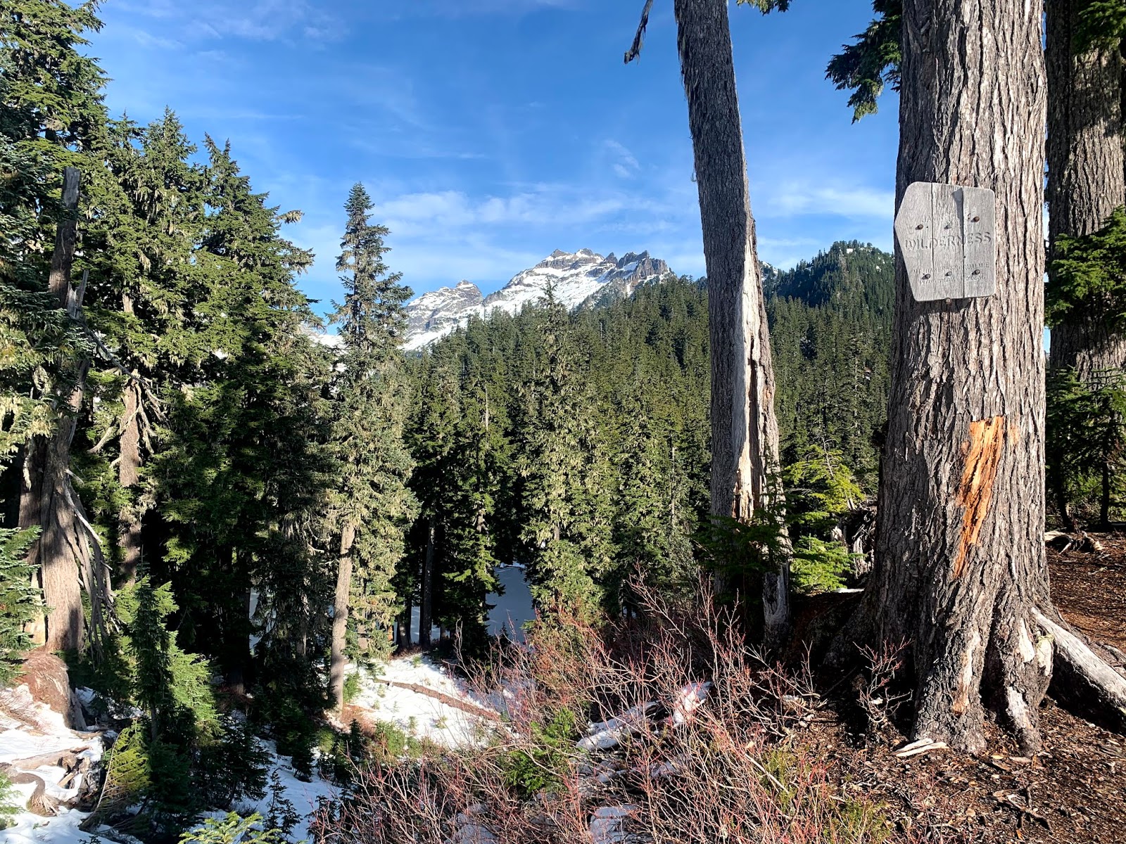
This hike soon enters the Wild Sky Wilderness and is mostly in the forest going uphill about 2,600 ft to the top of a ridge before dropping down about 700 ft to Blanca Lake. We found lots of ripe huckleberries along the trail on our way up the ridge.
Near the top of the ridge, we had a view of Glacier Peak to the east.
zoom of Glacier Peak 
The trail then enters the Henry M Jackson Wilderness and the trail descends and goes around Virgin Lake.
Reflection in Virgin Lake 
As the trail continues down, there are occasional views of nearby peaks.

Steep steps along part of the trail.

First views of Blanca Lake


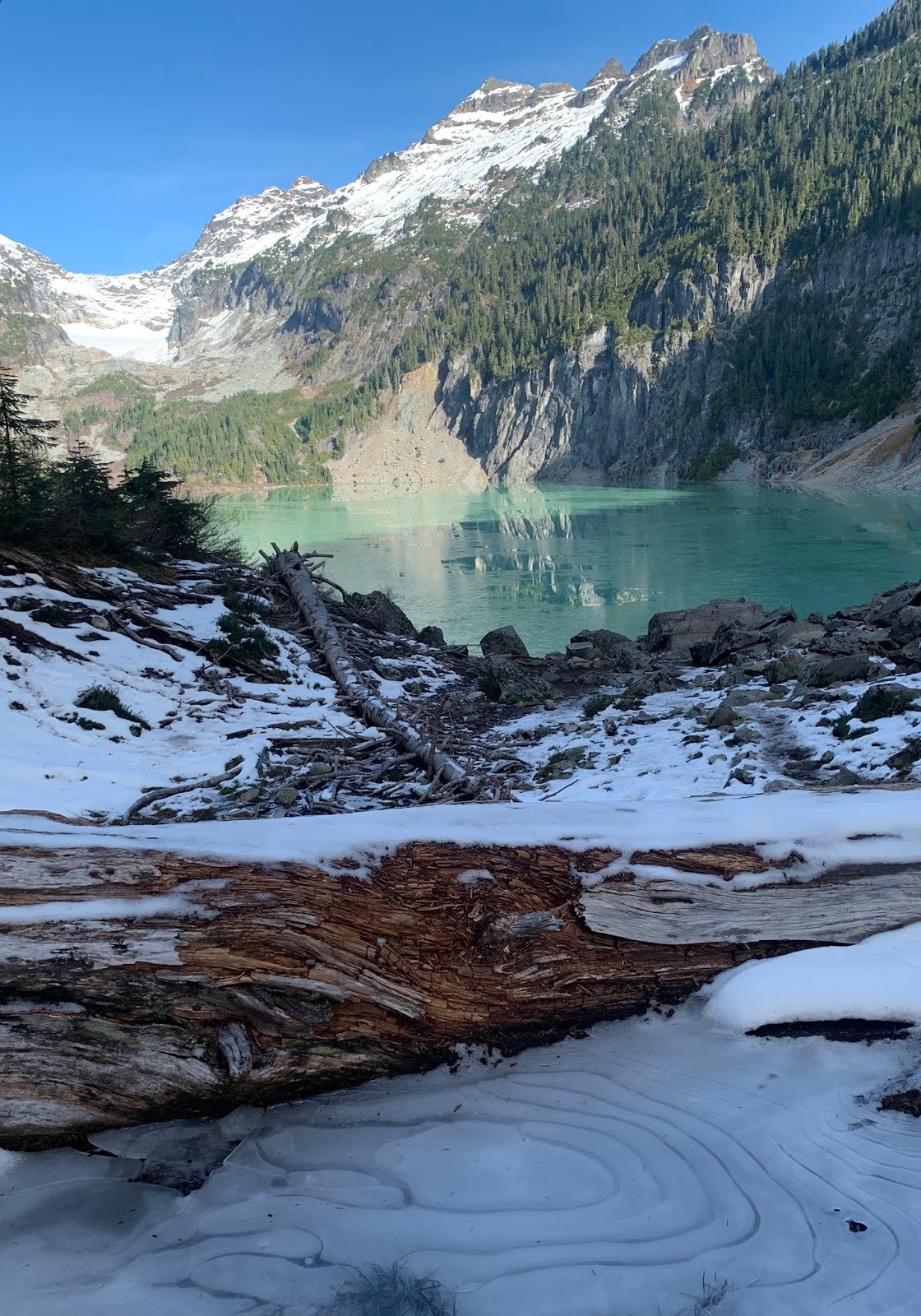
Blanca Lake at the shore, beautiful mountain reflections: Columbia Peak, Monte Cristo Peak, Kyes Peak

wide angle view of Blanca Lake, we had a nice lunch break here

Hiking back, last look at Blanca Lake
When we returned to the ridge, we could barely see Glacier Peak for the smoky haze starting to come westward. (zoom)

some of the flora seen along the trail today:


Saturday, November 2, 2019

Blanca Lake

 We drove up by Skykomish and took the Beckler Road to FS 65 and 63 and the newly reopened road to the Blance Lake Trailhead. This is a 7.5 mile round trip hike with an overall elevation gain of 3,300 ft.
 Although there were 9 cars in the parking area at 8 AM, we saw only 3 other hikers at the lake shore while we were at Blanca Lake on a sunny Saturday. Some hikers had already left lake. We saw many more friendly hikers on their way to the lake as we were returning down the trail.
 This trail begins in the Wild Sky Wilderness and is mostly in the forest. The trail climbs 2,650 ft in about 3 miles up to a ridge, before dropping 650 ft down to Blanc Lake over about 3/4 mile.


As we neared the ridge, we got a peak of the tops of Monte Cristo and Glacier Peak.

 zoom of Glacier Peak
 There were patches on snow and ice from going up to the ridge all the way down to Blanc Lake
 As we began descending down to Virgin Lake, we entered the Henry M Jackson Wilderness.


The trail goes around the east side of Virgin Lake, which was frozen today:
About 0.25 mile before reaching Blanca Lake, we took a short path to an overlook of Blanca Lake.

 Views from the overlook, great reflections of Columbia Peak and Monte Cristo in the lake.


 view as we descended down to the lake shore
 some frost and ice by the lake shore


We had a wonderful lunch break at the shore

 We found interesting ice formations along the edge of the lake
 Loved the symmetry of these logs and the mountain reflections in the lake.

found a benchmark near the outlet of the lake.

 Beautiful teal pond below the outlet of the lake
 The teal color of Blanca Lake seems to glow, here seen along the outlet.


 Today was a wonderful sunny November day, so glad I finally hiked up to Blanca Lake, gorgeous!!!


After our break, it was 650 ft of elevation gain back up to the ridge and then the descent to the trailhead.

 There was a little bit of fall color along the trail,
 and a few fungi as well.


Saturday, July 18, 2015

Benchmark Mountain via West Cady Ridge Summer Hike

A great view hike in the Wild Sky Wilderness & the Henry M Jackson Wilderness. The trailhead is 20 miles up Forest Service Roads north of Skykomish off of Hwy 2. The hike is 14. 4 miles round trip with about 3,700 ft of total elevation gain. Most of the wildflowers were well passed bloom, but the blueberries and blue huckleberries were ripe and the bushes went along the trail for miles!


The trail starts in the forest and soon crosses the North Fork of the Skykomish River on a nice bridge.


 Looking downstream North Fork of the Skykomish River
 Looking upstream: North Fork of the Skykomish River
The trail then begins to ascend up to West Cady Ridge through tall trees and many huckleberry and blueberry bushes. Here the trail gains 2,250 ft in 3.8 miles.
 Along the the top of West Cady Ridge, the trees begin to thin, and the surrounding mountains begin to appear.


Monte Cristo Peaks


Glacier Peak
and to the south, the peaks in the Enchantments


 For the next two miles, the trail goes up and down along the ridge, gaining another 750 ft, and enters the Henry M Jackson Wilderness.
We continued to have  great views, eating berries all along the trail


 Near 7 miles from the trail head, a side trail goes off to the left towards Benchmark Mountain, gaining 300 ft in the next 0.3 miles.
If you stay on the West Cady Ridge Trail, it will join the Pacific Crest Trail in less than a mile between Saddle Gap and Cady Pass.

The mountains surrounded us all as far as we could see.


 My siblings atop of Benchmark Mountain.
From Benchmark Mountain we had 360* views, the only man made object we could see was the trail, no evidence of clear cutting.


Panorama from Benchmark Mountain to the north: Monte Cristo Mountains, Mt Baker, Glacier Peak
 Panorama from Benchmark Mountain to the east: Glacier Peak and the North Cascades
 Panorama from Benchmark Mountain to the south:
 Panorama from Benchmark Mountain to the west:

 Close up of Mt Baker


Glacier Peak
We headed back down off of Benchmark Mountain,

to West Cady Ridge, this time hiking into the views!


Mt Rainier far to the south


one of the butterflies and some of the wildflowers and plants we saw along the trail today: