Showing posts with label Summit Lake. Show all posts

Wednesday, November 20, 2019

Summit Lake

We drove up the very rough FR 7810 (near the Carbon River entrance of Mt Rainer National Park) to hike up to Summit Lake in the Clearwater Wilderness. This road has lots of potholes, ruts and exposed rocks for 6.8 miles.
The hike is 6 miles round trip with an overall 1,400 ft of gain.
The trail climbs up through the forest.
About 0.9 mile from the trailhead, the trail reaches a T junction at Twin Lakes(Bearhead Mountain behind the lake), turn left to go to Summit Lake.
The trail passes a small pond, then begins to climb up a ridge towards Summit Lake.


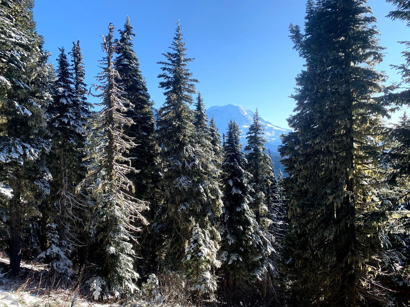
Along the ridge we had a peek of Mt Rainier through the trees.
There was a couple of inches of fresh snow.
Another frozen pond closer to Summit Lake.
2.5 miles from the trailhead we reached Summit Lake, We then hiked the loop trail around the lake, heading clockwise to go up the steep trail to the far end of the ridge on the opposite side of the lake, then descend on the gentler slope coming down the ridge back to the lake. The loop trail is about 1 mile.
Another view of the frozen pond near Summit Lake.
As we hiked around the lake, we saw this beautiful blue color in the lake.
Along the trail up to the ridge, we saw a boot track through the trees and found this lovely view of Bearhead Mountain and Mt Ranger.
Summit Lake to the north with views from Glacier Peak to Mount Stuart in the far distance, as we continued up the ridge.


Pano to the the south from the ridge top: Bearhead Mtn, Mt Rainier, the rim of Mt St Helens in the far distance and Copley Lake below.

To the northwest we could see clouds covering Puget Sound, distant Olympic Mtns and Mt Baker
As we hiked down the ridge, we had a fabulous view to the north from Mt Baker to Mount Stuart and many peaks in between.
Fresh snow on the trees around Summit Lake as we continued down the ridge.
There is a boot track to this gorgeous view spot. Summit Lake with Bearhead Mtn and Mt Rainier.
Small frozen puddles near Summit Lake
Looking back at  the ridge reflecting in Summit  Lake.
another small frozen pond near Summit Lake

\\\\\\\\\\\\\\\\\\\\\\\\\\\\\\\\\\\\\\\\\\\\\\\\

Tuesday, November 22, 2016

Summit Lake

Went to Summit Lake just north of the Carbon River in the Clearwater Wilderness and were surprised to find out we had the entire hike to ourselves. The weather was better than predicted, we had some sun, occasional views of Mt Rainier and no rain showers! it is 2.5 miles to the Lake and another mile to do the loop around the lake, so 6 miles with 1,300 ft of elevation gain.
We found snow along the trail a short ways into the hike.
There is a small waterfall under the bridge on the trail.

View of Bearhead Mtn from Twin Lake. This is where the trail divides, to the left: Summit Lake and to the right: Bearhead Mtn. We went left.
 A frozen pond a short ways up the trail.
 As the trail neared Summit Lake, we had a glimpse of Mt Rainier between the trees.
Pano as we neared Summit Lake. We decided to hike clockwise around the lake, going up the steeper section of the ridge first.

 A frozen pond near Summit Lake (the ice was very thin) be careful as the snow covers the edges of the pond.
 View of Summit Lake to the north, as we begin to climb up the ridge.
 When we first reached the top of the ridge, Mt Rainier was covered in clouds, but we had a nice view of Bearhead Mtn and Coplay Lake.
Pano from the ridge looking west towards Puget Sound
 Pano from the ridge looking east to south


 It was fun to watch the clouds moving across Mt Rainier.


 There are several spots along the trail where there are views of Mt Rainier hiking down the ridge.
 Wide angle of Summit Lake looking eastward. Far in the distance on the left, we saw Mt Stuart.


 What a beautiful day this turned out to be. We found it slippery on the way down the ridge, so used our micro spikes.


Pano from Summit Lake, where we stopped for a lunch break before hiking out.


Saturday, June 4, 2016

Summit Lake and Bearhead Mountain

 We drove out to hike up to Summit Lake and to Bearhead Mountain. These share the same trailhead for the first 0.8 mile. This trailhead is at the end of FSR 7810, north of the Carbon River across from Mount Rainer NP.
Most of the hike is in the woods (which was nice on a hot day), we did come across some downed trees.


 There is a small waterfall along the trail, a footbridge goes over the top.


We ran into snow as we neared the lake.
A little over 2 miles from the trailhead, we reached the pond on the east side of Summit Lake, it was still snow covered.


Our first view of Summit Lake, with the ridge we are headed to behind it. We decided to go up the ridge on the regular spur trail on the north side of Summit Lake.


 View part way up the ridge line looking to Bearhead Mountain, Mt Rainier and Summit Lake
 There was still snow on the ridge, but it was easy to find the way up.


Pano to the south from the top of the ridge. Bearhead Mountain, Mt Rainier, Coplay Lake (not seen in the photo, but we could see the top of Mt St Helens):
 Pano to the west, looking over towards the Olympic Mtns in the very far distance:
 Pano to the north, includes Mt Baker, Mt Shuksan, Glacier Peak, North Cascades, Teanaways and Mt Stuart along with Summit Lake below us:

We hiked back to where the trail splits at Twin Lake to head out to Bearhead Mountain. From here, it is 1.8 miles to the side trail going up to Bearhead Mountain.


 There are several views of Mt Rainier on the way up the 0.8 spur trail to Bearhead Mountain.


 We were near the top of the spur trail, before running into snow on the trail


When we reached the top of Bearhead Mountain, we had fabulous views to the north: Mt Baker, Mt Shuksan, Glacier Peak, North Cascades, Teanaways and Mt Stuart (pano)
And to the south: Mt Rainier (pano)
 some of the wildflowers and other flora we saw along the trail today: