Our first hike was the Grinnell Glacier Hike. It was our favorite hike in Glacier last August, a 12 mile round trip with 1,700 ft of elevation gain. Because of snow hazards, the trail was closed after 3.5 miles, making todays hike 7+ miles roundtrip with about 1,000 ft of elevation gain.
The trail starts in the forest on the way to Swiftcurrent Lake.
The trail soon travels along the west shore of Swiftcurrent Lake, a panoramic view of the south shore :
There is a short trail connecting Swiftcurrent Lake with Lake Josephine, we took the short spur to the boat dock on Lake Josephine's north shore, a panoramic view:
 We saw several rabbits along this portion of the trail
 The trail continues along the west shore of Lake Josephine.
Along the way, we saw an "iceberg" in a pond along the side of Lake Josephine
view of the "iceberg"
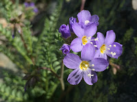
There were lots of wildflowers in bloom all along the trail
 From Lake Josephine, the trail is a steady climb upwards. We saw lots of streams along the trail as the snow is melting.
There were places where the water flowed across the trail
Wide angle view of Angel Wing, the Garden Wall with Salamander Glacier and Grinnell Glacier and Grinnell Lake:
 Part of the trail was lined with glacier lilies
More water along the trail
Wide angle photo further up the trail:
Here our trail was partially covered with snow
Panoramic view:
We love this trail!
further up the trail, we had several large snow fields to cross
We saw a small herd of bighorn sheep:
We decided to stop where the trail was closed, and found a spot to sit on the rocks, eat lunch and enjoy the views.
Panoramic view in front of us:
Panoramic view behind us: While we were eating lunch, we heard a loud thunderous noise and looked over to see an avalanche pouring over the trail we decided not to continue on. Here (zoom) it looks like a waterfall, it continued for 10 minutes.
We then returned back down the trail, another panorama, with Allen Mountain in the center:
As the day warmed up, the amount of water on the trail increased
 View near the end as we returned to the trailhead.
Some of the many wildflowers and blossoms we saw along the trail today:


No comments:
Post a Comment