

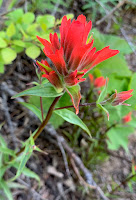
There were lots of wildflowers in bloom along the trail.
 View to the south as we hiked up to the ridge.
 On the ridge, our trail joined the Teanaway Ridge Trail. Iron Peak can be seen behind the trees on the left.
 As we continued up the trail, we could see Mt Rainier to the southwest in the distance.
 View to the northeast as we continued up towards Iron Bear.
 View of a distant Mount Stuart from near the top of Iron Bear.
 From Iron Bear, we could see Mt Adams, the Goat Rocks and Mt Rainier to the southwest,
some of the many wildflowers we saw along the trail:


No comments:
Post a Comment