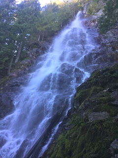
 Hiked up to Mount Teneriffe via the Kamikaze route today. First 3 miles is to the upper Teneriffe Falls with 770 ft of elevation gain (the last 1.5 miles is 3,000 ft of elevation gain) for a 4.5 mile, 3,800 ft gain hike. We came down the longer 7 mile route via an old logging road for a 11.5 mile hike today.
The first two miles are fairly flat, you want to make sure to follow the signs for Teneriffe Falls for the Kamikaze route up to the top. The second sign is found at 2 miles, and here the trail begins to go up steep switchbacks to the falls. There was lots of water in the creek.

View of lower Teneriffe Falls
View of upper Teneriffe Falls
a short distance before reaching upper Teneriffe Falls, the Kamikaze trail can be found going up (on the right side of the falls).
This is a steep trail, with very few turns, it mostly goes up
 The snow level was a bit lower than where I thought it would be. It was mostly soft on top and firm underneath, traction helped.
We had a few peek a boo views of Mt Rainier to the south through the trees as the trail continued to climb up.

There was one area where the snow was hard and icy and I found it difficult to make kick steps (no photo as we didn't want to stop in that section).

Here we are close to the summit, it is beyond the trees and up to the right.
A nice promontory, looking south, near the summit.
Wide angle view from the summit looking southwest. Mount Si and Blowdown Peak in the foreground. To the left, lie Rattlesnake Lake and Rattlesnake Ridge
zoom to the west: Seattle, Puget Sound and the Olympic Mountains.
Panorama to the east, we could see from Mt Baker to the north to Mt Rainier to the South.
 zoom to the north with Mt Baker on the left edge of the photo
zoom of Glacier Peak to the northeast
 view to the east, looking over the top edge of Mt Teneriffe
 The route down, was to descend off the top of Mt Teneriffe the same way we came up, until entering the woods.
instead of turning left to the south and the Kamikaze route, we would turn right, through the woods and follow the ridge to the north.
 Eventually, it is not possible to continue north with descending a very steep slope, so you turn west along another ridge, and eventually reach the old logging road and head towards Blowdown Peak and Mount Si. We were fortunate to have steps to follow from a couple who had come up this route today, and several other hikers who also decided to return this route instead of returning via the Kamikaze route. We found the steps well packed down and did not have much post holing today.There was snow on the road for a couple of miles.
 From further down the old road, looking back at Mount Teneriffe. You can see the snow covered cap on top, and the ridge line we followed to the north (left side of this photo) going up and down until joining the old road.
There were several creeks crossing the road, and near the end of the trail, a couple of bridges crossing larger streams.
We saw some wild violets and berry blossoms on the lower trail.


No comments:
Post a Comment