Friday, March 31, 2017

Pyramid Mountain hike

In the afternoon, we headed to the North Shore of Lake Crescent to hike the Pyramid Mountain trail. From the parking area across the road, this is a 7.2 mile round trip hike with 2,400 ft of elevation gain. After crossing the road, there is a short paved section that switchbacks up towards the trailhead.

The majority of this hike is in the forest. There are a few areas where streams cross the trail.


 The trail has a nice gradient climbing up the flank of Pyramid Mountain for the first 1.75 miles.
 An old landslide took out a section of the trail, and it has been replaced with a narrow foot path over the slide area.


The landslide die open up a view of part of Lake Crescent and the Olympic Mountains to the south.


There is a lot of exposure on this section of the trail, be careful of your foot placement.


 After the landslide, the trail begins to climb more steeply. We found several downed trees along the trail, none to difficult to maneuver over or under.
There are a couple of sections where the trail levels out for a short time.

 Near the top, the trail crosses a saddle and another view of Lake Crescent appears.

 A short steep section leads up to an old plane spotter hut atop Pyramid Mountain.


Between the trees are some nice views of the lake 2,500 ft below.
Western end of Lake Crescent and nestled in the hills lies Lake Sutherland. Beyond the hills, we could see Mt Baker peaking through the clouds.

 Across the lake to the south lies Mount Storm King, where we hiked this morning.

Another view of Lake Crescent to the south. Far below we could spot the dock by the lodge at Storm King.

Mount Storm King and Marymere Falls Hike

 We headed out to the Lake Crescent area of Olympic National Park to do some hikes today. We started at the Storm King Ranger Station on the south shore to Combine the hike up Mount Storm King with the hike to Marymere Falls in the morning. (4.8 miles rt with 2,200 ft of elevation gain).


 The trail goes through a tunnel under Hwy 101.
 After 1/2 mile, the trail splits, Mount Storm King to the left, Marymere Falls to the right.
We chose to head up Mount Storm King first, we could gain 2,000 ft in elevation in less than 1.5 miles.
After gaining about 1,350 ft in less than a mile, reach the first viewpoint overlooking Lake Cresent. Beyond the peaks to the north, lays the Straight of Juan de Fuca and Vancouver Island in Canada.

Another 400 ft of elevation gain over 1/2 mile leads to the second viewpoint.


The trail here is narrow and has exposure, so be careful where you step. This is where the maintained trail on Mount Storm King ends.

 Many hikers continue up the 250-300 ft scramble up to a rocky ledge for great views.
Sometimes hikers leave ropes over the steep loose scree sections of the scramble. (These are not placed or maintained by the park)


There are no ropes along the final rocky ledge.
 The ledge is narrow, uneven and has over 1,000 ft drop offs on both side.
But the panoramic view of Lake Crescent is fabulous! Pyramid Mountain is across the lake. On a clear day, the Strait of Juan de Fuca, Vancouver Islands and the North Cascade mountains can be seen in the distance.

 After enjoying the view, we returned back down the trail to the junction and hiked 1/2 mile through the forest to Marymere Falls. A bridge crosses Barnes Creek.
 There is a loop trail going up 200 ft on the way to view the falls.

 Marymere Falls (90 ft) from the lower viewpoint.


 Marymere Falls from the upper viewpoint

On the walk back to the trailhead, we spotted this large boulder that looked like a moss covered skull.

Tuesday, March 28, 2017

Horsetail Falls Loop

 There was still a lot of daylight after our Coyote Wall Hike, so we decided to do a short waterfall hike on the Oregon side of the Columbia Gorge.
We chose the Horsetail Falls Loop hike, 2.6 miles with 610 ft of elevation gain.

 Horsetail Falls (176 ft) is right next to the Historic Hwy at the start of the trail.

Although this trail is mostly in the forest, there were several places where we had view overlooking the Columbia River


About 1/2 mile up the trail is Ponytail Falls (88 ft), the trail continues behind these falls.
Pano view from behind Ponytail Falls:

 View of Ponytail Falls from the other side of the trail.
The trail levels out after Ponytail Falls, and is a nice walk in a beautiful forest.
 View overlooking the Columbia River
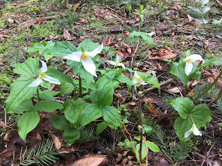
 Trillium in bloom
 Lots of moss covered trees
The trail passes by a large weeping wall. Today there was almost enough water coming over to be a waterfall.

 Lower section of the weeping wall.

 The trail then drops down via switchbacks to the bridge over Oneota Creek in the Oneota Gorge.
 Looking down Oneota Gorge as the creeks travels down to the Columbia River.
 The trail crosses this bridge over Oneota Creek.
 Middle Oneota Falls (15 ft)
 The trail then continues down to the Historic Hwy, crossing a couple of other trails. We saw a few places where water was spilling over the rock walls along the trail.

 A distant waterfall
old moss covered stone wall.

 The trail joins the Historic Hwy for 1/2 mile walk back to Horsetail Falls. Before the trail goes through a tunnel,
 it crosses the north end of Oneota Creek.
 I took the short, very wet, trail up the side of the creek, where water was spilling over the rock walls.
 Too much water in the creek to look up into the Gorge, so I returned back to the Historic Hwy.
The loop ends back at Horsetail Falls.


Not on the trail, but a short drive down the Historic Hwy took us to Mutlanomah Falls.